Shcholkine
Shcholkine
Щолкіне Щёлкино Şçolkino | |
|---|---|
 | |
| Coordinates: 45°25′25″N 35°49′7″E / 45.42361°N 35.81861°E | |
| Country | |
| Autonomous republic | Crimea (de jure) |
| Raion | Kerch Raion (de jure) |
| Federal subject | Crimea (de facto) |
| District | Lenine District (de facto) |
| Area | |
| • Total | 3.42 km2 (1.32 sq mi) |
| Elevation | 20 m (70 ft) |
| Population (2014) | |
| • Total | 10,620 |
| • Density | 3,100/km2 (8,000/sq mi) |
| Time zone | UTC+3 (MSK) |
| Postal code | 98213 |
| Area code | +7-36557 |
| 1 Autonomous Republic of Crimea (de jure) or Republic of Crimea (de facto), depending on jurisdiction. | |
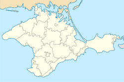
Shcholkine (Ukrainian: Щолкіне, Ukrainian pronunciation: [ˈʃt͡ʃɔlʲkʲine]; Russian: Щёлкино, romanized: Shcholkino; Crimean Tatar: Şçolkino), also commonly known as Shchelkino or Shchyolkino by its Russian name, is a small city in the Lenine Raion of Crimea. Geographically, Shcholkine is located near the headland of Kazantyp, on a peninsula jutting northward out into the Sea of Azov from the Crimean mainland. Population: 11,677 (2001); 10,620 (2014 Census).[1]
History
[edit]
Shcholkine is named after Kirill Shchelkin, a Soviet physicist. Originally the town was constructed in 1978 to house workers of the Crimean Atomic Energy Station (nuclear power plant). The station was inspected following the Chernobyl disaster of 1986, and was found to be located on a geologically volatile site. Construction of the facility was summarily abandoned.
Shcholkine is known for being an increasingly popular tourist destination and dacha site. Shcholkine's beach has boat and surfboard rental facilities. Nearby Kazantyp is home to several attractions including a local fairground and paintball competitions. The town itself has a central market, many cafes and stores, and entertainment facilities including a movie theater and an internet cafe. The town's main attraction is considered to be its beach, a kilometer-long sandbar sandwiched between cliffs jutting out over the Sea of Azov to the south and Kazantyp to the northwest. Between 1993 and 1999 Kazantyp was the site of the KaZantip music festival, which later (2001-2013) moved to the little village of Popivka near Yevpatoria.
Demographics
[edit]The 2001 Ukrainian Census recorded the population of Shcholkine as 11,677 persons. Ethnically the population is predominantly Russian, Ukrainian, and Crimean Tatar. Major religions can be assumed to include atheism or agnosticism[citation needed], Eastern Orthodox Christianity, and Islam, although there is only one church in Shcholkine's immediate vicinity. The lingua franca in the town is Russian, while the Ukrainian language is natively spoken by a significant minority and in educational institutions, as well as by tourists from mainland Ukraine. The Crimean Tatar language is rarely used in the city.[2][3]
The Crimean census of 2014 recorded the population at 15,450 persons, around 5,000 of which were refugees the Crimean Tatar population mostly fled to mainland Ukraine.
References
[edit]- ^ Russian Federal State Statistics Service (2014). "Таблица 1.3. Численность населения Крымского федерального округа, городских округов, муниципальных районов, городских и сельских поселений" [Table 1.3. Population of Crimean Federal District, Its Urban Okrugs, Municipal Districts, Urban and Rural Settlements]. Федеральное статистическое наблюдение «Перепись населения в Крымском федеральном округе». ("Population Census in Crimean Federal District" Federal Statistical Examination) (in Russian). Federal State Statistics Service. Retrieved January 4, 2016.
- ^ "Рідні мови в об'єднаних територіальних громадах України". socialdata.org.ua.
- ^ "Національний склад міст".
External links
[edit]- Shcholkine (Russian)
- The Cape Kazantip
- The Kazantip Nature Reserve (English)


