Shaogongzhuang Subdistrict
Appearance
Shaogongzhuang Subdistrict
邵公庄街道 | |
|---|---|
 Tianjin West Railway Station on the northeast of the subdistrict, 2016 | |
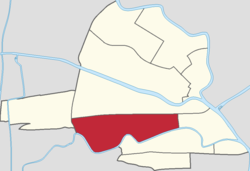
 Location of Shaogongzhuang Subdistrict in Hongqiao District | |
| Coordinates: 39°09′12″N 117°08′56″E / 39.15333°N 117.14889°E | |
| Country | China |
| Municipality | Tianjin |
| District | Hongqiao |
| Village-level Divisions | 13 communities |
| Area | |
| • Total | 2.88 km2 (1.11 sq mi) |
| Elevation | 7 m (23 ft) |
| Population (2010) | |
| • Total | 54,413 |
| • Density | 19,000/km2 (49,000/sq mi) |
| Time zone | UTC+8 (China Standard) |
| Postal code | 300122 |
| Area code | 022 |
Shaogongzhuang Subdistrict (simplified Chinese: 邵公庄街道; traditional Chinese: 邵公莊街道; pinyin: Shàogōngzhuāng Jiēdào) is a subdistrict located in the south of Hongqiao District, Tianjin, China. It borders Xigu Subdistrict to the north, Santiaoshi Subdistrict to the east, Jieyuan Subdistrict to the southeast, Changhong and Xiangyang Road Subdistrict to the south, as well as Xiyingmen and Heyuan Subdsitricts to the west. It had 54,413 inhabitants as of 2010.[1]
The subdistrict was founded in 1952. Its name literally means "Mr. Shao‘s Manor’.[2]
Geography
[edit]Shaogongzhuang subdistrict situates north of the Nanyun River.
Administrative divisions
[edit]At the end of 2021, Shaogongzhuang Subdistrict was divided into 13 residential communities. They are listed as follows:[3]
| Subdivision Names | Name Transliterations |
|---|---|
| 建设里 | Jiansheli |
| 中联 | Zhonglian |
| 西青道第二 | Xiqingdao Di'er |
| 西青道第三 | Xiqingdao Disan |
| 西青道第四 | Xiqingdao Disi |
| 杨庄子 | Yangzhuangzi |
| 咸阳 | Xianyang |
| 前园 | Qianyuan |
| 幸福里第二 | Xingfuli Di'er |
| 幸福里第一 | Xingfuli Diyi |
| 洛川里 | Luochuanli |
| 仁爱花园 | Ren'ai Huayuan |
| 千禧园 | Qianxiyuan |
See also
[edit]References
[edit]- ^ "China: Tiānjīn Municipal Province (Districts and Townships) - Population Statistics, Charts and Map". www.citypopulation.de. Retrieved 2022-11-05.
- ^ 中华人民共和国政区大典:天津市卷 (in Chinese). 中国社会出版社. 2020.
- ^ "2021年统计用区划代码和城乡划分代码". www.stats.gov.cn. Retrieved 2022-12-22.


