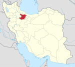
Shal, Qazvin
Appearance
(Redirected from Shal)
Shal
Persian: شال | |
|---|---|
City | |
| Coordinates: 35°53′57″N 49°46′08″E / 35.89917°N 49.76889°E[1] | |
| Country | Iran |
| Province | Qazvin |
| County | Buin Zahra |
| District | Shal |
| Population (2016)[2] | |
• Total | 15,290 |
| Time zone | UTC+3:30 (IRST) |
| Shal, Qazvin at GEOnet Names Server | |
Shal (Persian: شال)[3] is a city in, and the capital of, Shal District of Buin Zahra County, Qazvin province, Iran.[4]
Demographics
[edit]Population
[edit]At the time of the 2006 National Census, the city's population wa 15,104 in 3,348 households.[5] The following census in 2011 counted 14,996 people in 3,972 households.[6] The 2016 census measured the population of the city as 15,290 people in 4,217 households.[2]
Economy
[edit]Shal is historically known as a center of sheep breeding.[7]: 858
In literature
[edit]The 14th-century author Hamdallah Mustawfi listed Shal as one of the main villages in the territory of Qazvin.[8]
See also
[edit]References
[edit]- ^ OpenStreetMap contributors (14 September 2024). "Shal, Buin Zahra County" (Map). OpenStreetMap (in Persian). Retrieved 14 September 2024.
- ^ a b Census of the Islamic Republic of Iran, 1395 (2016): Qazvin Province. amar.org.ir (Report) (in Persian). The Statistical Center of Iran. Archived from the original (Excel) on 30 November 2021. Retrieved 19 December 2022.
- ^ Shal, Qazvin can be found at GEOnet Names Server, at this link, by opening the Advanced Search box, entering "-3084351" in the "Unique Feature Id" form, and clicking on "Search Database".
- ^ "Shal city". lastsecond.ir (in Persian). Listekand Family. 27 April 2018. Archived from the original on 14 September 2024. Retrieved 14 September 2024.
- ^ Census of the Islamic Republic of Iran, 1385 (2006): Qazvin Province. amar.org.ir (Report) (in Persian). The Statistical Center of Iran. Archived from the original (Excel) on 20 September 2011. Retrieved 25 September 2022.
- ^ Census of the Islamic Republic of Iran, 1390 (2011): Qazvin Province. irandataportal.syr.edu (Report) (in Persian). The Statistical Center of Iran. Archived from the original (Excel) on 19 January 2023. Retrieved 19 December 2022 – via Iran Data Portal, Syracuse University.
- ^ Lambton, Ann K.S.; Hillenbrand, R.M. (1978). "ḲAZWĪN". In Van Donzel, E.; Lewis, B.; Pellat, Ch. (eds.). The Encyclopaedia of Islam, Volume IV (IRAN-KHA). Leiden: E.J. Brill. pp. 857–63. ISBN 90 04 05745 5. Retrieved 8 April 2022.
- ^ Hamdallah Mustawfi (1919). Le Strange, Guy (ed.). The Geographical Part of the Nuzhat-al-Qulub. p. 64. Retrieved 10 October 2022.


