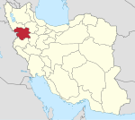
Shahrak-e Hejrat, Kurdistan
Appearance
Shahrak-e Hejrat
Persian: شهرك هجرت | |
|---|---|
Former Village | |
| Coordinates: 35°28′24″N 46°11′46″E / 35.47333°N 46.19611°E[1] | |
| Country | Iran |
| Province | Kurdistan |
| County | Marivan |
| District | Central |
| Rural District | Sarkal |
| Population (2006)[2] | |
• Total | 4,441 |
| Time zone | UTC+3:30 (IRST) |
Shahrak-e Hejrat (Persian: شهرك هجرت) was a village in Sarkal Rural District of the Central District of Marivan County, Kurdistan province, Iran.
Demographics
[edit]Ethnicity
[edit]The village was populated by Kurds.[3]
Population
[edit]At the time of the 2006 National Census, the village's population was 4,441 in 1,082 households.[2] After the census, the former village of Kani Dinar merged with Shahrak-e Hejrat to establish the city of Kani Dinar.[4]
See also
[edit]References
[edit]- ^ OpenStreetMap contributors (19 August 2023). "Shahrak-e Hejrat, Marivan County" (Map). OpenStreetMap (in Persian). Retrieved 19 August 2023.
- ^ a b "Census of the Islamic Republic of Iran, 1385 (2006)". AMAR (in Persian). The Statistical Center of Iran. p. 12. Archived from the original (Excel) on 20 September 2011. Retrieved 25 September 2022.
- ^ Mohammadirad, Masoud; Anonby, Erik; et al. "Language distribution in Kordestan Province, Iran". Atlas of the languages of Iran (ALI). Geomatics and Cartographic Research Centre, Carleton University. Archived from the original on 28 May 2023.
- ^ Davoudi, Parviz (31 May 2009). "The government's agreement with three changes in the country divisions of Razavi Khorasan and Kurdistan". Ministry of Interior (in Persian). Ministry of Interior, Cabinet of Ministers. Archived from the original on 4 March 2016. Retrieved 17 August 2023.


