Serebryanka (Moscow Oblast)
Appearance
| Serebryanka | |
|---|---|
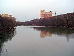
 The Serebryanka in Pushkino | |
 | |
| Location | |
| Country | Pushkinsky District, Moscow Oblast, Russia |
| Physical characteristics | |
| Mouth | Ucha |
• coordinates | 55°59′27″N 37°51′28″E / 55.99083°N 37.85778°E |
| Length | 13 km (8.1 mi) |
| Basin features | |
| Progression | Ucha→ Klyazma→ Oka→ Volga→ Caspian Sea |
The Serebryanka (Russian: Серебрянка) is a river in Moscow Oblast, Russia, a tributary of the Ucha. It flows through Pushkinsky District. The river starts in the village of Stepankovo and ends in Pushkino city, where it is confined by a levee near its mouth. There is a boat station on the river that holds rowing competitions. The total length of the river is 13 km.[1]
References
[edit]- ^ «Река Серебрянка», Russian State Water Registry
