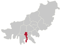
Seo District, Busan
Appearance
Seo
서구 | |
|---|---|
| Korean transcription(s) | |
| • Hanja | 西區 |
| • Revised Romanization | Seo-gu |
| • McCune–Reischauer | Sŏ-gu |
 Seo District and Namhang Bridge | |
 | |
| Country | South Korea |
| Region | Yeongnam |
| Provincial level | Busan |
| Administrative divisions | 14 administrative dong |
| Area | |
| • Total | 13.67 km2 (5.28 sq mi) |
| Population (September 2024[1]) | |
| • Total | 103,197 |
| • Density | 7,500/km2 (20,000/sq mi) |
| • Dialect | Gyeongsang |
| Website | Seo District Office |

Seo District (Korean: 서구; RR: Seo-gu; lit. West District) is a gu, or district, in south-west central Busan, South Korea.
Administrative divisions
[edit]
Seo-gu is divided into 8 legal dong, which altogether comprise 14 administrative dong, as follows:
- Dongdaesin-dong/East Daesin (3 administrative dong)
- Seodaesin-dong/West Daesin (3 administrative dong)
- Bumin-dong
- Ami-dong
- Chojang-dong
- Chungmu-dong
- Nambumin-dong/South Bumin (3 administrative dong)
- Amnam-dong
In 1998 Ami 1-dong and Ami 2-dong were merged. In 2003 Seodaesin 2-dong and Seodaesin 1-dong were merged.
The district contains the island Dudo.[2]
Politics
[edit]The area is represented in the National Assembly by the West District and East District Busan (South Korean Legislature Constituency)
Sister cities
[edit]See also
[edit]References
[edit]- ^ "Population statistics". Korea Ministry of the Interior and Safety. 2024.
- ^ 김, 성환. 두도(頭島) - 부산역사문화대전. Encyclopedia of Korean Local Culture. Retrieved 2024-08-09.
External links
[edit]Wikimedia Commons has media related to Seo-gu, Busan.
- Seo-gu website (in English)
35°06′N 129°01′E / 35.10°N 129.02°E


