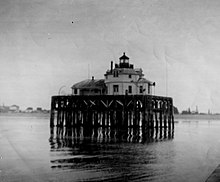
Semiahmoo Harbor Light
Appearance
 Semiahmoo Harbor Light (USCG/1943) | |
 | |
| Location | Blaine, Washington |
|---|---|
| Coordinates | 48°59′32″N 122°47′03″W / 48.99219°N 122.78406°W |
| Tower | |
| Constructed | 1905 |
| Foundation | Piling |
| Construction | Wood |
| Shape | Octagonal |
| Light | |
| First lit | 1905 |
| Deactivated | 1944 |
| Lens | Fourth order Fresnel lens |
| Characteristic | F R (–Unknown) |
The Semiahmoo Harbor Lighthouse was a lighthouse on Semiahmoo (/ˌsɛmiˈɑːmoʊ/ SEM-ee-AH-moh) Bay near the port of Blaine, Whatcom County, Washington, in the United States.[1]
History
[edit]The station consisted of a 1½-story dwelling built on a platform supported by wooden piles, with a lantern at the center of its peaked roof.[1] It was constructed in 1905, using the same design by U.S. Lighthouse Board Architect Carl Leick used at the Desdemona Sands Lighthouse at the mouth of the Columbia River.[2][3] The light was deactivated and the entire structure torn down in 1944.[2][4][5]
References
[edit]- ^ a b "Historic Light Station Information and Photography: Washington". United States Coast Guard Historian's Office. Archived from the original on 2017-05-01. Retrieved November 28, 2008.
- ^ a b Dougherty, Phil (May 6, 2012). "The Semiahmoo Lighthouse activates its light on June 5, 1905". The Online Encyclopedia of Washington State History. HistoryLink. Retrieved May 27, 2015.
- ^ "Desdemona Sands Light on the Columbia River". Rudy and Alice's Lighthouse page. Archived from the original on January 5, 2011. Retrieved 2008-11-23.
- ^ "Semiahmoo Harbor Light (Washington)—Historical Light List Characteristics and Optics and Structures". United States Lighthouse Society. Archived from the original on 2008-12-01. Retrieved 2008-11-28.
- ^ "The Lost History of Washington's Semiahmoo Lighthouse". Lighthouse Digest. Foghorn Press. November 2005. Retrieved May 27, 2015.

