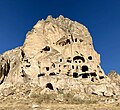
Selime, Güzelyurt
Selime | |
|---|---|
 | |
| Coordinates: 38°18′N 34°16′E / 38.300°N 34.267°E | |
| Country | Turkey |
| Province | Aksaray |
| District | Güzelyurt |
| Population (2021) | 1,796 |
| Time zone | UTC+3 (TRT) |
| Area code | 0382 |
Selime formerly known as Salamis (Ancient Greek: Σαλαμίς) is a town (belde) and municipality in the Güzelyurt District, Aksaray Province, Turkey.[1] Its population is 1,796 (2021).[2]
History
[edit]In these fairy chimneys lived Christians fleeing from Romans. When Christianity was accepted in Rome, churchs and cathedrals were built here.
There is a battle castle on a hill there. the Byzantines fought Ali Pasha from the Seljuk Dynasty in this castle. Ali Pasha became a martyr. Selime Tomb was built for him. Also, since this place was under the rule of Ottoman for many years, the Ottomans built Sinan Bey Mosque (1524) here.
Selime; It is one of the chimneys of volcano with heights of Hasan Mountain 3258 m, Melendiz Mountain 3000 m, Göllü Mountain 2650 m, which became active about 10 million years ago in the Upper Miocene period. This is a region where the precursor material cold tuffs that come out and cover a large area, then the tuffs that came into contact with the volcanic heat, and then the materials that flow from the craters and spread over the flat plain and form a layer of a certain thickness, is here. Natural events occurring over many millions of years "erosion; earthquakes, annual temperature difference, snow, rain, wind and [[Melendiz Stream] passing nearby ]] has provided this region with a magnificent natural look.
Selime became a municipality on July 1, 1992, with the status of municipality.[3]
Places of Interest
[edit]- Selime Cathedral
- Selime Peri Bacalari
- Selime Sultan Tomb
Gallery
[edit]-
Selime castle
-
Church inside Selime castle
-
Selime Cathedral with a view of Selime in the background.
-
Inside Selime Cathedral
-
Selime Cathedral seen from below
See also
[edit]References
[edit]- ^ Belde, Turkey Civil Administration Departments Inventory. Retrieved 15 January 2023.
- ^ "Address-based population registration system (ADNKS) results dated 31 December 2021" (XLS) (in Turkish). TÜİK. Retrieved 12 January 2023.
- ^ "Decisions on the Establishment of the Municipality" (PDF) (in Turkish). Official Gazette. 9 July 1992. Archived (PDF) from the original on 1 August 2014. Retrieved June 1, 2022.


