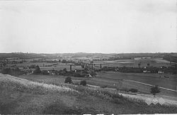
Savci
Appearance
Savci | |
|---|---|
 Postcard of Savci | |
| Coordinates: 46°28′31.09″N 16°2′42.31″E / 46.4753028°N 16.0450861°E | |
| Country | |
| Traditional region | Styria |
| Statistical region | Drava |
| Municipality | Sveti Tomaž |
| Area | |
| • Total | 5.87 km2 (2.27 sq mi) |
| Elevation | 225.2 m (738.8 ft) |
| Population (2002) | |
| • Total | 241 |
| [1] | |
Savci (pronounced [ˈsaːu̯tsi]) is a settlement in the Slovene Hills (Slovene: Slovenske gorice) in the Municipality of Sveti Tomaž in northeastern Slovenia. The area is part of the traditional region of Styria and is now included in the Drava Statistical Region.[2]
The village chapel with a belfry was built in 1895.[3]
Notable people
[edit]Notable people that were born or lived in Savci include:
- Stanko Cajnkar (1900–1977), writer[4][5]
References
[edit]- ^ Statistical Office of the Republic of Slovenia
- ^ Sveti Tomaž municipal site
- ^ Slovenian Ministry of Culture register of national heritage reference number 20156
- ^ "Stanko Cajnkar". Ognjišče. Retrieved January 13, 2018.
- ^ Janež, Stanko (1953). Pregled zgodovine Jugoslovanskih književnosti: Slovenska književnost. Ljubljana: Založba obzorja. p. 530.
External links
[edit] Media related to Savci at Wikimedia Commons
- Savci on Geopedia


