Santuario, Risaralda
5°4′20.87″N 75°57′44.45″W / 5.0724639°N 75.9623472°W
Santuario, Risaralda | |
|---|---|
Municipality and town | |
 Street of Santuario | |
| Nickname: Pearl of The Tatamá | |
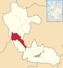
 Location of the municipality and town of Santuario, Risaralda in the Risaralda Department of Colombia. | |
| Country | |
| Department | Risaralda Department |
| Area | |
| • Total | 201 km2 (78 sq mi) |
| Elevation | 1,565 m (5,135 ft) |
| Population (2023) | |
| • Total | 12,826 |
| • Density | 64/km2 (170/sq mi) |
| Time zone | UTC-5 (Colombia Standard Time) |
Santuario is a town and municipality in the Department of Risaralda, Colombia. About 64 km away from the capital Pereira. In 2023 the town had an estimated population of 12,826.[2]
History
[edit]Founded in 1906, Santuario was born under the administrative tutelage of Anserma and towards part of the state of Cauca. In 1982 it became dependent on the newly created municipality of San Antonio de Apía, a year later the first school was created and in 1894 it ceased to be a hamlet and was declared a township, becoming a parish in 1906. In 1907, it was erected as a Municipality.[3]
Climate
[edit]Santuario has a subtropical highland climate with an average annual temperature of 20°C.[4]
| Climate data for Santuario (Camelia La), elevation 1,650 m (5,410 ft), (1981–2010) | |||||||||||||
|---|---|---|---|---|---|---|---|---|---|---|---|---|---|
| Month | Jan | Feb | Mar | Apr | May | Jun | Jul | Aug | Sep | Oct | Nov | Dec | Year |
| Mean daily maximum °C (°F) | 23.8 (74.8) |
24.1 (75.4) |
24.0 (75.2) |
23.4 (74.1) |
23.4 (74.1) |
23.5 (74.3) |
23.9 (75.0) |
24.3 (75.7) |
23.9 (75.0) |
23.1 (73.6) |
22.9 (73.2) |
23.2 (73.8) |
23.6 (74.5) |
| Daily mean °C (°F) | 19.1 (66.4) |
19.4 (66.9) |
19.4 (66.9) |
19.3 (66.7) |
19.2 (66.6) |
19.3 (66.7) |
19.6 (67.3) |
19.7 (67.5) |
19.2 (66.6) |
18.7 (65.7) |
18.7 (65.7) |
18.9 (66.0) |
19.2 (66.6) |
| Mean daily minimum °C (°F) | 16.1 (61.0) |
16.2 (61.2) |
16.3 (61.3) |
16.3 (61.3) |
16.4 (61.5) |
16.3 (61.3) |
16.2 (61.2) |
16.3 (61.3) |
16.1 (61.0) |
15.9 (60.6) |
15.9 (60.6) |
16.1 (61.0) |
16.2 (61.2) |
| Average precipitation mm (inches) | 111.2 (4.38) |
116.7 (4.59) |
144.9 (5.70) |
207.3 (8.16) |
214.5 (8.44) |
176.2 (6.94) |
148.7 (5.85) |
136.9 (5.39) |
169.1 (6.66) |
218.8 (8.61) |
217.2 (8.55) |
139.5 (5.49) |
2,001.1 (78.78) |
| Average precipitation days | 14 | 13 | 17 | 20 | 20 | 17 | 16 | 14 | 17 | 21 | 20 | 16 | 199 |
| Average relative humidity (%) | 84 | 83 | 84 | 85 | 86 | 84 | 81 | 79 | 82 | 85 | 86 | 86 | 84 |
| Mean monthly sunshine hours | 155.0 | 138.3 | 130.2 | 111.0 | 117.8 | 126.0 | 173.6 | 173.6 | 138.0 | 108.5 | 108.0 | 127.1 | 1,607.1 |
| Mean daily sunshine hours | 5.0 | 4.9 | 4.2 | 3.7 | 3.8 | 4.2 | 5.6 | 5.6 | 4.6 | 3.5 | 3.6 | 4.1 | 4.4 |
| Source: Instituto de Hidrologia Meteorologia y Estudios Ambientales[5] | |||||||||||||
Tourism
[edit]One of the main characteristics of the town is the yearly observance of religious holidays and local fairs.
Sites of interest
- Tatamá National Natural Park
- Maria Inmaculada's Church
- Calle Real

References
[edit]- ^ "Municipalities of Colombia". statoids. Retrieved 28 April 2020.
- ^ Telefónicas, Telencuestas-Encuestas. "Cuántos habitantes tiene Santuario, Risaralda en 2023". Telencuestas (in Spanish). Retrieved 2023-09-28.
- ^ Risaralda, Gobernación de (2016-09-28). "Santuario". Gobernación de Risaralda (in Spanish). Retrieved 2023-09-28.
- ^ "Santuario – Risaralda un destino lleno de vida" (in Spanish). Retrieved 2023-09-28.
- ^ "Promedios Climatológicos 1981–2010" (in Spanish). Instituto de Hidrologia Meteorologia y Estudios Ambientales. Archived from the original on 15 August 2016. Retrieved 17 June 2024.

