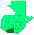
Santa Lucía Cotzumalguapa
Appearance
(Redirected from Santa Lucia Cotzumalguapa)
Santa Lucía Cotzumalguapa | |
|---|---|
Municipality and town | |
| Coordinates: 14°21′00″N 91°01′00″W / 14.35000°N 91.01667°W | |
| Country | |
| Department | Escuintla Department |
| Area | |
• Total | 200 sq mi (530 km2) |
| Elevation | 1,220 ft (372 m) |
| Population (2018 census)[1] | |
• Total | 112,780 |
| • Density | 550/sq mi (210/km2) |
| Climate | Am |
Santa Lucía Cotzumalguapa (Spanish pronunciation: [ˈsanta luˈsi.a kotsumalˈɣwapa]) is a town, with a population of 58,877 (2018 census),[2] and a municipality in the Escuintla department of Guatemala.
The municipality includes the Cotzumalhuapa archaeological zone, including the pre-Columbian archaeological sites of El Baúl and Bilbao. It is the birthplace of president Carlos Castillo Armas.
Climate
[edit]Santa Lucía Cotzumalguapa has a tropical monsoon climate (Köppen: Am).
| Climate data for Santa Lucía Cotzumalguapa | |||||||||||||
|---|---|---|---|---|---|---|---|---|---|---|---|---|---|
| Month | Jan | Feb | Mar | Apr | May | Jun | Jul | Aug | Sep | Oct | Nov | Dec | Year |
| Mean daily maximum °C (°F) | 31.3 (88.3) |
31.8 (89.2) |
32.9 (91.2) |
32.9 (91.2) |
32.4 (90.3) |
31.4 (88.5) |
31.4 (88.5) |
31.3 (88.3) |
30.5 (86.9) |
30.5 (86.9) |
30.5 (86.9) |
31.0 (87.8) |
31.5 (88.7) |
| Daily mean °C (°F) | 24.7 (76.5) |
25.2 (77.4) |
26.3 (79.3) |
26.7 (80.1) |
26.7 (80.1) |
26.1 (79.0) |
26.0 (78.8) |
26.0 (78.8) |
25.6 (78.1) |
25.4 (77.7) |
25.0 (77.0) |
24.9 (76.8) |
25.7 (78.3) |
| Mean daily minimum °C (°F) | 18.2 (64.8) |
18.7 (65.7) |
19.7 (67.5) |
20.5 (68.9) |
21.0 (69.8) |
20.8 (69.4) |
20.7 (69.3) |
20.7 (69.3) |
20.7 (69.3) |
20.3 (68.5) |
19.6 (67.3) |
18.9 (66.0) |
20.0 (68.0) |
| Average precipitation mm (inches) | 12 (0.5) |
16 (0.6) |
41 (1.6) |
114 (4.5) |
351 (13.8) |
517 (20.4) |
415 (16.3) |
437 (17.2) |
574 (22.6) |
502 (19.8) |
149 (5.9) |
28 (1.1) |
3,156 (124.3) |
| Source: Climate-Data.org[3] | |||||||||||||
Sports
[edit]The town has a team that plays in the Liga Nacional de Guatemala, the top division soccer league in Guatemala.
See also
[edit]Notes and references
[edit]- ^ Citypopulation.de Population of departments and municipalities in Guatemala
- ^ Citypopulation.de Population of cities & towns in Guatemala
- ^ "Climate: Santa Lucía Cotzumalguapa". Climate-Data.org. Retrieved 24 August 2015.
- ^ a b SEGEPLAN. "Municipios de Escuintla, Guatemala". Secretaría General de Planificación y Programación de la Presidencia de la República. Guatemala. Archived from the original on 14 July 2015. Retrieved 13 July 2015.


