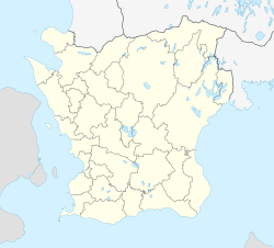
Sankt Olof
Appearance
Sankt Olof | |
|---|---|
 | |
| Coordinates: 55°38′N 14°08′E / 55.633°N 14.133°E | |
| Country | Sweden |
| Province | Skåne |
| County | Skåne County |
| Municipality | Simrishamn Municipality |
| Area | |
• Total | 0.73 km2 (0.28 sq mi) |
| Population (31 December 2010)[1] | |
• Total | 624 |
| • Density | 850/km2 (2,200/sq mi) |
| Time zone | UTC+1 (CET) |
| • Summer (DST) | UTC+2 (CEST) |
Sankt Olof is a locality situated in Simrishamn Municipality, Skåne County, Sweden with 624 inhabitants in 2010.[1]
Sankt Olof is a village located 15 miles northwest of Simrishamn. The village is named after the church, which in its turn is named after Olaf II of Norway, the village was originally called Lunkende.
References
[edit]- ^ a b c "Tätorternas landareal, folkmängd och invånare per km2 2005 och 2010" (in Swedish). Statistics Sweden. 14 December 2011. Archived from the original on 27 January 2012. Retrieved 10 January 2012.
External links
[edit]


