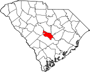
Sandy Run, South Carolina
Sandy Run is an unincorporated community in Calhoun County, South Carolina, United States. Its elevation is 154 feet (47 m).[1] Sandy Run is best known for hosting the United States Marine Corps semi-annual Mud Run. Sandy Run is named after a local stream, Sandy Run, which flows through Sandy Run and neighboring communities, Gaston and Swansea which flows into the Congaree River. Those who live in Sandy Run have a Gaston or Swansea address.
The William Baker House was listed in the National Register of Historic Places in 1978.[2] William T. Sherman may have slept there in February 1865.[3]
Sandy Run is home of the USMC Mud Run, held annually.[4]
Economy
[edit]Sandy Run is home to many large corporations such as DAK Americas.[5]
Sandy Run has in its core several small local businesses including Sandy Run Nursery, a family owned nursery for several generations, and Sandy Run Florist and Sandwich Shop. Nearby Ruck's Engine Repair can fix your lawnmower.
Development
[edit]Recently (May, 2019) Sandy Run has gone through a major development overhaul. A feasibility study outlined 3 possible scenarios for future land development.[6] As of November, 2019 most of the construction has been completed, which includes road improvements, zoning, and the construction of several factories.
Transportation
[edit]During lane reversals (during Hurricane evacuations) Sandy Run sees detour traffic from the busy interstate I-26.
References
[edit]- ^ U.S. Geological Survey Geographic Names Information System: Sandy Run, South Carolina
- ^ "National Register Information System". National Register of Historic Places. National Park Service. July 9, 2010.
- ^ HOLLEMAN, JOEY. "Sherman slept there -- probably in a Calhoun County plantation home". The State. The State. Retrieved November 28, 2019.
- ^ Rose, Martha. "Sandy Run holds Mud Run". The T and D. The T and D. Retrieved November 28, 2019.
- ^ "Dak Americas locations". Dak Americas. Retrieved November 28, 2019.
- ^ County, Calhoun. "Sandy Run Land Use" (PDF). Calhoun County. Retrieved November 28, 2019.
33°48′00″N 80°57′50″W / 33.80000°N 80.96389°W

