San Quintín Municipality
Appearance
(Redirected from San Quintin Municipality)
San Quintín Municipality
Municipio de San Quintín | |
|---|---|
| Motto: ' | |
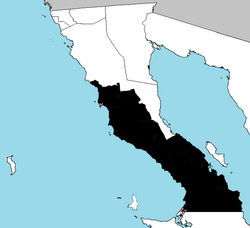
 Location of San Quintín in Baja California prior to the creation of San Felipe. | |
| Coordinates: 32°34′N 116°38′W / 32.567°N 116.633°W | |
| Country | Mexico |
| State | |
| Founded | 27 February 2020 |
| Seat | San Quintín |
| Largest city | San Quintín |
| Area | |
• Total | 32,883.93 km2 (12,696.56 sq mi) |
| Population (2020) | |
• Total | 117,568 |
| • Density | 3.6/km2 (9.3/sq mi) |
| Data source: [1] | |
| Time zone | UTC−8 (Northwest (US Pacific)) |
| • Summer (DST) | UTC−7 (Northwest) |
| INEGI code | 006 |
San Quintín is a municipality in the Mexican state of Baja California. Its municipal seat is located in the city of San Quintín, Baja California. According to the 2020 census, it had a population of 117,568 inhabitants.[2] The municipality has an area of 32,883.93 km2 (12,696.55 sq mi). There are a few National Parks and a World Heritage Site at Bahia de Los Angeles.
History
[edit]On 27 February 2020 San Quintin separated from the municipality of Ensenada, and became Baja California's sixth municipality.
Administrative divisions
[edit]
| Year | Pop. | ±% |
|---|---|---|
| 2020 | 117,568 | — |
| [3][4][5][6] | ||
The municipality is divided into 8 delegations:
- Camalú
- Vicente Guerrero
- San Quintín
- El Rosario
- El Mármol
- Punta Prieta
- Bahía de los Ángeles
- Villa Jesús María.
Localities
[edit]The municipality is made up of many localities. Its urban localities in 2010 were:
- Lázaro Cárdenas (16,294)
- Vicente Guerrero (11,455)
- Camalú (8,621)
- Emiliano Zapata (5,756)
- San Quintín (4,777)
- Colonia Lomas de San Ramón (Triquis) (3,805)
- Ejido Papalote (3,413)
- Colonia Nueva Era (3,256)
- Colonia Santa Fe (2,632)
References
[edit]- ^ "México en cifras". January 2016.
- ^ "México en cifras". January 2016.
- ^ "Localidades y su población por municipio según tamaño de localidad" (PDF) (in Spanish). INEGI. Archived from the original (PDF) on 31 August 2018. Retrieved 15 July 2017.
- ^ "Número de habitantes". INEGI (National Institute of Statistics and Geography). Archived from the original on 2 July 2017. Retrieved 15 July 2017.
- ^ "Tabulados de la Encuesta Intercensal 2015" (xls) (in Spanish). INEGI. Archived from the original on 31 December 2017. Retrieved 15 July 2017.
- ^ "INEGI. Censo de Población y Vivienda 2020. Tabulados del Cuestionario Básico – Aguascalientes" [INEGI. 2020 Population and Housing Census. Basic Questionnaire Tabulations – Aguascalientes] (Excel) (in Spanish). INEGI. 2020. pp. 1–4. Archived from the original on 28 January 2021. Retrieved 27 January 2021.
Wikimedia Commons has media related to San Quintín Municipality.


