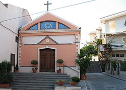
San Pier Niceto
Appearance

San Pier Niceto
Σαν Πιέρ Νικέτο | |
|---|---|
| Comune di San Pier Niceto | |
| Coordinates: 38°10′N 15°21′E / 38.167°N 15.350°E | |
| Country | Italy |
| Region | Sicily |
| Metropolitan city | Messina (ME) |
| Frazioni | San Pier Marina, Serro, Zifronte, Pirrera |
| Area | |
| • Total | 36.3 km2 (14.0 sq mi) |
| Elevation | 260 m (850 ft) |
| Population (Dec. 2004)[2] | |
| • Total | 3,084 |
| • Density | 85/km2 (220/sq mi) |
| Demonym | Sanpietresi |
| Time zone | UTC+1 (CET) |
| • Summer (DST) | UTC+2 (CEST) |
| Postal code | 98045 |
| Dialing code | 090 |
| Website | Official website |
San Pier Niceto (Sicilian: San Pieru Nicetu) is a comune (municipality) in the Province of Messina in the Italian region Sicily, located about 170 kilometres (110 mi) east of Palermo and about 20 kilometres (12 mi) west of Messina. As of 31 December 2004, it had a population of 3,084 and an area of 36.3 square kilometres (14.0 sq mi).[3]
The municipality of San Pier Niceto contains the frazioni (subdivisions, mainly villages and hamlets) San Pier Marina, Serro, Zifronte, and Pirrera.
San Pier Niceto borders the following municipalities: Condrò, Fiumedinisi, Gualtieri Sicaminò, Monforte San Giorgio, Pace del Mela, Santa Lucia del Mela.
Demographic evolution
[edit]
References
[edit]- ^ "Superficie di Comuni Province e Regioni italiane al 9 ottobre 2011". Italian National Institute of Statistics. Retrieved 16 March 2019.
- ^ "Popolazione Residente al 1° Gennaio 2018". Italian National Institute of Statistics. Retrieved 16 March 2019.
- ^ All demographics and other statistics: Italian statistical institute Istat.
External links
[edit]


