San Pedro Riparian National Conservation Area
| San Pedro Riparian National Conservation Area | |
|---|---|
IUCN category V (protected landscape/seascape) | |
 San Pedro River at the Little Boquillas Ranch. | |
| Location | Cochise County, Arizona, United States |
| Nearest city | Sierra Vista, Arizona |
| Coordinates | 31°34′58″N 110°07′53″W / 31.5829°N 110.1313°W |
| Area | 57,000 acres (23,000 ha) |
| Established | 1988 |
| Governing body | Bureau of Land Management |
| www | |
The San Pedro Riparian National Conservation Area (San Pedro Riparian NCA; SPRNCA) contains nearly 57,000 acres (23,000 ha) of public land in Cochise County, Arizona, between the international border with Mexico and St. David, Arizona. The riparian area, where some 40 miles (64 km) of the upper San Pedro River meanders, was, through the efforts of congressman Jim Kolbe,[1] designated by Congress as a Riparian National Conservation Area on November 18, 1988, and assigned to the protection of the U.S. Bureau of Land Management (BLM).[2]
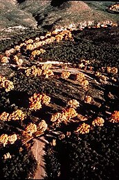
One of the most important riparian areas in the United States,[3] the San Pedro River runs through the Chihuahuan and Sonoran Desert transition zone in southeastern Arizona. The river's stretch in the southern San Pedro Valley is home to 84 species of mammals, 14 species of fish, 41 species of reptiles and amphibians, and 100 species of breeding birds. It also provides invaluable habitat for 250 species of migrant and wintering birds and contains archaeological sites representing the remains of human occupation from 13,000 years ago.[2]
In addition to protecting the San Pedro River's rare ecosystem for future generations, the BLM also works to stabilize and preserve several historic buildings and structures located throughout much of the San Pedro Riparian NCA, including those of the Fairbank Historic Townsite, the Little Boquillas Ranch and the San Pedro House. The San Pedro House is located along the river to the east of Sierra Vista and is a fully restored historic ranch house dating to the 1930s. It is now used as a visitor center and bookstore for the San Pedro Riparian NCA.[2][4]
In April 2022, the San Pedro River was named as one of America's Most Endangered Rivers.[3] Later in 2022, environmental protection groups, including the Center for Biological Diversity, the Western Watersheds project and the Sierra Club challenged the BLM’s proposal to expand livestock grazing in the protected area. In a lawsuit, they questioned whether cattle grazing was compatible with protecting against excess erosion and protecting the indigenous wildlife.[5][6]
Gallery
[edit]
|
See also
[edit]References
[edit]- ^ Cohn, R. J. (December 7, 2022). "Remembering Rep. Jim Kolbe: A lawmaker who went to bat for Cochise County". Herald/Review. Sierra Vista, Arizona. Archived from the original on January 1, 2023.
- ^ a b c "San Pedro Riparian NCA – BLM Arizona". Retrieved June 10, 2023.
- ^ a b "San Pedro River Named Among America's Most Endangered Rivers of 2022". Earthjustice. April 19, 2022. Archived from the original on April 19, 2022.
- ^ Stewart, Ron (2013). "The Boquillas Land Grant and the Evictions of 1906" (PDF). Friends of the San Pedro River Roundup. Friends of the San Pedro River. Retrieved January 19, 2015.
- ^ Frederico, Jake (December 31, 2022). "BLM plan to renew grazing allotments near the San Pedro River imperils habitat, groups say". Arizona Republic. Archived from the original on January 1, 2023.
- ^ Ellis, Emily (July 25, 2023). "The legislative history behind today's legal battles in the SPRNCA". Herald/Review. Cochise County, Arizona.
External links
[edit] Media related to San Pedro Riparian National Conservation Area at Wikimedia Commons


