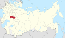
Samara Governorate
Appearance
| Samara Governorate Самарская губерния | |
|---|---|
| Governorate of the Russian Empire | |
| 1850–1928 | |
 Location within the Russian Empire | |
| Capital | Samara |
| Population | |
• 1897 | 2,751,336 |
| History | |
• Established | 1850 |
• Disestablished | 14 May 1928 |
Samara Governorate (Russian: Самарская губерния, romanized: Samarskaya guberniya) was an administrative-territorial unit (guberniya) of the Russian Empire and the Russian SFSR, located in the Volga Region. It existed from 1850 to 1928; its capital was in Samara.[1]
Samara Governate under the Russian Empire
[edit]Administrative divisions
[edit]From its foundation until 1918 the governorate was divided into seven uyezds (counties). These were:[1]

| No. | Uezd | County town | Coat of Arms of the county town |
Area, Square miles |
Population[2] (1897) |
|---|---|---|---|---|---|
| 1 | Bugulminsky | Bugulma (7 581 pop.) | 
|
10 803,1 | 299 884 |
| 2 | Buguruslansky | Buguruslan (12 109 pop.) | 
|
17 068,7 | 405 994 |
| 3 | Buzuluksky | Buzuluk (14 362 pop.) | 
|
22 427,0 | 492 952 |
| 4 | Nikolayevsky | Nikolaevsk (12 504 pop.) | 
|
28 196,9 | 494 736 |
| 5 | Novouzensky | Novouzensk (13 261 pop.) | 
|
34 585,9 | 417 376 |
| 6 | Samarsky | Samara (89 999 pop.) | 13 155,4 | 357 018 | |
| 7 | Stavropolsky | Stavropol (5 969 pop.) | 
|
10 476,5 | 283 376 |
Samara Governorate in the post revolutionary period until abolition (1928)
[edit]References
[edit]- ^ a b "Самарская губерния" [Samara Governorate]. Brockhaus and Efron Encyclopedic Dictionary (in Russian). St. Petersburg. 1900.
{{cite encyclopedia}}: CS1 maint: location missing publisher (link) - ^ "The first general census of the population of the Russian Empire in 1897. The actual population in the provinces, districts, cities of the Russian Empire (without Finland)". Institute of Demography, National Research University Higher School of Economics. 10 January 2012. Archived from the original on 2012-01-10. Retrieved 9 June 2023.
53°11′00″N 50°07′00″E / 53.1833°N 50.1167°E

