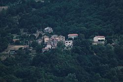
Salaiola
Appearance
Salaiola | |
|---|---|
 View of Salaiola | |
| Coordinates: 42°52′11″N 11°30′04″E / 42.86972°N 11.50111°E | |
| Country | Italy |
| Region | |
| Province | Grosseto (GR) |
| Comune | Arcidosso |
| Elevation | 740 m (2,430 ft) |
| Population (2011) | |
• Total | 34 |
| Demonym | Salaiolesi |
| Time zone | UTC+1 (CET) |
| • Summer (DST) | UTC+2 (CEST) |
| Postal code | 58031 |
| Dialing code | (+39) 0564 |
Salaiola is a village in Tuscany, central Italy, administratively a frazione of the comune of Arcidosso, province of Grosseto, in the area of Mount Amiata. At the time of the 2001 census its population amounted to 39.[1]
Salaiola is about 55 km from Grosseto and 8 km from Arcidosso, and it is situated on the slopes of Mount Aquileia, one of the peaks of Mount Amiata. Here once stood the early medieval village of Roveta.
Main sights
[edit]- Church of the Madonna, main parish church of the village, built in 1863.
- Chapel of San Girolamo, old chapel of Casal Roveta.
- Casal Roveta, old farmhouse situated near the village, it is the last evidence of the ancient settlement of Roveta.
References
[edit]Bibliography
[edit]- Aldo Mazzolai, Guida della Maremma. Percorsi tra arte e natura, Le Lettere, Florence, 1997
See also
[edit]Wikimedia Commons has media related to Salaiola.

