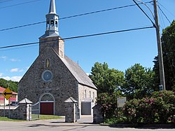
Saint-François-de-l'Île-d'Orléans
Saint-François-de-l'Île-d'Orléans | |
|---|---|
 Church of Saint-François-de-l'Île-d'Orléans | |
 Location within L'Île-d'Orléans RCM | |
| Coordinates: 47°00′N 70°49′W / 47.000°N 70.817°W[1] | |
| Country | Canada |
| Province | Quebec |
| Region | Capitale-Nationale |
| RCM | L'Île-d'Orléans |
| Settled | 1670s |
| Constituted | July 1, 1855 |
| Government | |
| • Mayor | Lina Labbé |
| • Federal riding | Montmorency—Charlevoix —Haute-Côte-Nord |
| • Prov. riding | Charlevoix–Côte-de-Beaupré |
| Area | |
| • Total | 102.80 km2 (39.69 sq mi) |
| • Land | 28.96 km2 (11.18 sq mi) |
| Population | |
| • Total | 536 |
| • Density | 18.5/km2 (48/sq mi) |
| • Pop 2016-2021 | |
| • Dwellings | 359 |
| Time zone | UTC−5 (EST) |
| • Summer (DST) | UTC−4 (EDT) |
| Postal code(s) | |
| Area code(s) | 418 and 581 |
| Highways | |
| Website | msfio |
Saint-François-de-l'Île-d'Orléans is a municipality in the Capitale-Nationale region of Quebec, Canada, part of the L'Île-d'Orléans Regional County Municipality. The village is situated on the north-eastern tip of Orléans Island, and the municipality also includes the Madame and Ruau Islands, part of the Montmagny Archipelago.
Prior to December 20, 2003, it was known simply as Saint-François.[4]
History
[edit]The Parish of Saint-François-de-Sales was founded in 1679, named after Francis de Sales (1567-1622) and calling to mind Francois Berthelot, Comte de Jouy and de Saint-Laurent, representative of Paris in parliament and Seigneur of Île d'Orléans (1675) at the time the parish was established. It was also known as just Saint-François, and maps of the seventeenth and eighteenth centuries would show either one or the other form. In 1845, the Parish Municipality of Saint-François-Isle-d'Orléans was formed, but abolished in 1847 when it became part of the County Municipality. In 1852, the local post office opened. In 1855, the parish municipality was reestablished.[1]
In 2003, the Parish Municipality of Saint-François changed its statutes and was renamed to the Municipality of Saint-François-de-l'Île-d'Orléans.[1]
Demographics
[edit]Population
[edit]| 2021 | 2016 | 2011 | |
|---|---|---|---|
| Population | 536 (+1.7% from 2016) | 527 (0.0% from 2011) | 527 (-8.0% from 2006) |
| Land area | 28.96 km2 (11.18 sq mi) | 28.84 km2 (11.14 sq mi) | 29.21 km2 (11.28 sq mi) |
| Population density | 18.5/km2 (48/sq mi) | 18.3/km2 (47/sq mi) | 18.0/km2 (47/sq mi) |
| Median age | 55.6 (M: 56.8, F: 54) | 54.6 (M: 54.0, F: 55.8) | 52.9 (M: 51.6, F: 54.1) |
| Private dwellings | 255 (total) | 384 (total) | 359 (total) |
| Median household income | $81,000 | $67,840 | $.N/A |
|
| ||||||||||||||||||||||||||||||||||||||||||||||||||||||||||||||||||||||||||||||
| Source: Statistics Canada[10] | |||||||||||||||||||||||||||||||||||||||||||||||||||||||||||||||||||||||||||||||
Language
[edit]| Canada Census Mother Tongue - Saint-François-de-l'Île-d'Orléans, Quebec[10] | ||||||||||||||||||
|---|---|---|---|---|---|---|---|---|---|---|---|---|---|---|---|---|---|---|
| Census | Total | French
|
English
|
French & English
|
Other
| |||||||||||||
| Year | Responses | Count | Trend | Pop % | Count | Trend | Pop % | Count | Trend | Pop % | Count | Trend | Pop % | |||||
2021
|
540
|
525 | 97.2% | 10 | 1.9% | 5 | 0.9% | 0 | 0.0% | |||||||||
2016
|
530
|
515 | 97.2% | 5 | 0.9% | 5 | 0.9% | 5 | 0.9% | |||||||||
2011
|
530
|
505 | 95.3% | 15 | 2.8% | 0 | 0.0% | 10 | 1.9% | |||||||||
2006
|
575
|
550 | 95.7% | 15 | 2.6% | 0 | 0.0% | 10 | 1.7% | |||||||||
2001
|
490
|
490 | 100.0% | 0 | 0.0% | 0 | 0.0% | 0 | 0.0% | |||||||||
1996
|
490
|
490 | n/a | 100.0% | 0 | n/a | 0.0% | 0 | n/a | 0.0% | 0 | n/a | 0.0% | |||||
Government
[edit]List of former mayors:
- Yoland Dion (2001–2009)
- Lina Labbé (2009–present)
See also
[edit]References
[edit]- ^ a b c "Saint-François-de-l'Île-d'Orléans (Municipalité)" (in French). Commission de toponymie du Québec. Retrieved 2009-10-27.
- ^ a b "Répertoire des municipalités: Geographic code 20005". www.mamh.gouv.qc.ca (in French). Ministère des Affaires municipales et de l'Habitation.
- ^ a b https://www12.statcan.gc.ca/census-recensement/2021/dp-pd/prof/details/page.cfm?LANG=F&GENDERlist=1&STATISTIClist=1,4&DGUIDlist=2021A00052420005&HEADERlist=20,37,44,43,40&SearchText=Saint-Francois-de-l%27ile
- ^ "Archived copy" (PDF). Archived from the original (PDF) on 2004-02-05. Retrieved 2012-03-25.
{{cite web}}: CS1 maint: archived copy as title (link) - ^ "2021 Community Profiles". 2021 Canadian census. Statistics Canada. February 4, 2022. Retrieved 2022-04-27.
- ^ "2016 Community Profiles". 2016 Canadian census. Statistics Canada. August 12, 2021. Retrieved 2021-04-26.
- ^ "2011 Community Profiles". 2011 Canadian census. Statistics Canada. March 21, 2019. Retrieved 2014-04-18.
- ^ "2006 Community Profiles". 2006 Canadian census. Statistics Canada. August 20, 2019.
- ^ "2001 Community Profiles". 2001 Canadian census. Statistics Canada. July 18, 2021.
- ^ a b 1996, 2001, 2006, 2011, 2016, 2021 census

