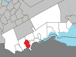
Saint-Alexis-de-Matapédia
Saint-Alexis-de-Matapédia | |
|---|---|
 | |
 Location within Avignon RCM | |
| Coordinates: 47°58′N 67°03′W / 47.967°N 67.050°W[1] | |
| Country | Canada |
| Province | Quebec |
| Region | Gaspésie– Îles-de-la-Madeleine |
| RCM | Avignon |
| Constituted | July 1, 1855 |
| Government | |
| • Mayor | Cynthia Dufour |
| • Federal riding | Gaspésie— Îles-de-la-Madeleine |
| • Prov. riding | Bonaventure |
| Area | |
• Total | 85.07 km2 (32.85 sq mi) |
| • Land | 84.91 km2 (32.78 sq mi) |
| Population (2021)[3] | |
• Total | 519 |
| • Density | 6.1/km2 (16/sq mi) |
| • Pop (2016–21) | |
| • Dwellings | 285 |
| Time zone | UTC−5 (EST) |
| • Summer (DST) | UTC−4 (EDT) |
| Postal code(s) | |
| Area code(s) | 418 and 581 |
| Highways | No major routes |
| Website | www.matapedia lesplateaux.com |
Saint-Alexis-de-Matapédia is a village and municipality in the Gaspésie–Îles-de-la-Madeleine region of eastern Quebec, Canada.
In addition to Saint-Alexis-de-Matapédia itself, the municipality also includes the communities of Léonard-de-Matapédia and Saint-Benoît-de-Matapédia.
Its name comes from Alexis Mailloux (1801-1877), a Roman Catholic vicar general who presided over the founding of the parish, and from the Matapedia river and township, in turn from the Mi'kmaq word matapegiag, meaning "river which forks".[1]
History
[edit]
The place was first incorporated in 1845 as the Township Municipality of Matapédia. Its first inhabitants were Acadians from Rustico, Prince Edward Island, who arrived around 1860. That same year, a mission was established that became a parish in 1870.[1]
The local post office opened in 1866 under the name Avignon, but was renamed to Saint-Alexis-de-Matapédia in 1922. Sometime before the 1920s, the municipality had changed its status and name to the Parish Municipality of Saint-Alexis-de-Matapédia.[1]
In 1966, the Municipality of Saint-Benoit was merged into Saint-Alexis-de-Matapédia.[4]
In 2003, the Parish Municipality of Saint-Alexis-de-Matapédia changed statutes to become a regular municipality.[1]
Demographics
[edit]| 2021 | 2016 | 2011 | |
|---|---|---|---|
| Population | 519 (+3.8% from 2016) | 500 (-8.8% from 2011) | 548 (-12.3% from 2006) |
| Land area | 84.91 km2 (32.78 sq mi) | 84.09 km2 (32.47 sq mi) | 84.40 km2 (32.59 sq mi) |
| Population density | 6.1/km2 (16/sq mi) | 5.9/km2 (15/sq mi) | 6.5/km2 (17/sq mi) |
| Median age | 58.8 (M: 56.8, F: 61.2) | 57.3 (M: 56.3, F: 58.4) | 54.3 (M: 52.5, F: 57.1) |
| Private dwellings | 285 (total) 249 (occupied) | 283 (total) 232 (occupied) | 286 (total) |
| Median household income | $48,000 | $39,765 | $34,713 |
|
|
| |||||||||||||||||||||||||||||||||||||||||||||||||||||||||||||||
| Population counts are not adjusted for boundary changes. Source: Statistics Canada[4][10] | |||||||||||||||||||||||||||||||||||||||||||||||||||||||||||||||||
See also
[edit]References
[edit]- ^ a b c d e "Banque de noms de lieux du Québec: Reference number 380542". toponymie.gouv.qc.ca (in French). Commission de toponymie du Québec.
- ^ a b "Répertoire des municipalités: Geographic code 06050". www.mamh.gouv.qc.ca (in French). Ministère des Affaires municipales et de l'Habitation. Retrieved 2024-04-10.
- ^ a b "Saint-Alexis-de-Matapédia (Code 2406050) Census Profile". 2021 census. Government of Canada - Statistics Canada. Retrieved 2024-04-10.
- ^ a b "1971 Census of Canada - Population Census Subdivisions (Historical)". Catalogue 92-702 Vol I, part 1 (Bulletin 1.1-2). Statistics Canada: 76, 139. July 1973.
- ^ "2021 Community Profiles". 2021 Canadian census. Statistics Canada. February 4, 2022. Retrieved 2022-04-27.
- ^ "2016 Community Profiles". 2016 Canadian census. Statistics Canada. August 12, 2021. Retrieved 2024-04-10.
- ^ "2011 Community Profiles". 2011 Canadian census. Statistics Canada. March 21, 2019. Retrieved 2014-01-29.
- ^ "2006 Community Profiles". 2006 Canadian census. Statistics Canada. August 20, 2019.
- ^ "2001 Community Profiles". 2001 Canadian census. Statistics Canada. July 18, 2021.
- ^ 1996, 2001, 2006, 2011 census

