Saadnayel
Saadnayel
سعدنايل | |
|---|---|
Town | |
 | |
| Coordinates: 33°49′12″N 35°52′58″E / 33.82000°N 35.88278°E | |
| Country | |
| Governorate | Beqaa Governorate |
| District | Zahlé |
| Elevation | 2,990 ft (910 m) |
| Time zone | UTC+2 (EET) |
| • Summer (DST) | +3 |
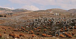
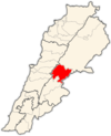
Saadnayel (Arabic: سعدنايل) is a town in the Bekaa Valley in the Zahlé District of Lebanon. It has a population of around 20,000 Lebanese, mostly Sunni Muslims.[1][2]
Saadnayel lies 47 kilometres (29 mi) from Beirut.[3] The town is located strategically near the crossroads between the Beirut-Damascus highway and the main road connecting the northern and southern Beqaa.[4]
History
[edit]In 1838, Eli Smith noted Saadnayel's population being Sunni Muslim.[5]
The town has been the site of sporadic Sunni-Shia violence. In 2008, four individuals were wounded in armed clashes between anti-Syrian majority supporters and Hezbollah-led opposition in Lebanon; the clashes involved use of machine guns, mortars, and rockets in Saadnayel. Despite the army's presence, they did not intervene.[6]
Up to 35,000 refugees of the Syrian Civil War have also settled in the town.[7]
References
[edit]- ^ Rami Ruhayem (9 September 2014). "Is Islamic State heading for Lebanon?". BBC News. Retrieved 8 December 2015.
- ^ Nour Samaha (26 January 2015). "'Here the dead are dead, and the living are dead'". Al Jazeera America. Retrieved 8 December 2015.
- ^ "Saadnayel". Localiban. 13 February 2008. Retrieved 8 December 2015.
- ^ Michael Young (13 Apr 2010). The Ghosts of Martyrs Square: An Eyewitness Account of Lebanon's Life Struggle (illustrated ed.). Simon and Schuster. p. 226. ISBN 978-1-4391-0945-8.
- ^ Robinson and Smith, 1841, vol 3, 2nd appendix, p. 142
- ^ "Four wounded in Lebanon sectarian clashes". Al Arabiya News. 9 June 2008. Retrieved 8 December 2015.
- ^ Nour Samaha (26 January 2015). "'Here the dead are dead, and the living are dead'". Al Jazeera America. Retrieved 8 December 2015.


