Sõmerpalu Parish
Appearance
Sõmerpalu Parish
Sõmerpalu vald (in Estonian) Sõmmõrpalo vald (in Võro) | |
|---|---|
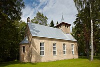
 Heimtali Peetri church | |
 Sõmerpalu Parish within Võru County. | |
| Country | |
| County | |
| Administrative centre | Sõmerpalu |
| Area | |
| • Total | 181.93 km2 (70.24 sq mi) |
| Population (01.01.2016) | |
| • Total | 1,771 |
| • Density | 9.7/km2 (25/sq mi) |
| Website | www.somerpalu.ee |
Sõmerpalu Parish (Estonian: Sõmerpalu vald; Võro: Sõmmõrpalo vald) was a rural municipality of Estonia, in Võru County. It had a population of 1,771 (as of 1 January 2016) and an area of 181.93 km².[1]
Settlements
[edit]- Small borough
- Villages
Alakülä - Alapõdra - Haava - Haidaku - Haamaste - Hänike - Hargi - Heeska - Horma - Hutita - Järvere - Kahro - Kärgula - Keema - Kurenurme - Lakovitsa - Leiso - Liiva - Lilli-Anne - Linnamäe - Mäekülä - Majala - Mustassaare - Mustja - Osula - Pritsi - Pulli - Punakülä - Rauskapalu - Rummi - Sõmerpalu - Sulbi - Udsali - Varese
Images
[edit]See also
[edit]References
[edit]- ^ "Population figure and composition". stat.ee. Statistics Estonia. Retrieved 27 January 2010.
External links
[edit]- Official website (in Estonian)
57°51′2″N 26°49′35″E / 57.85056°N 26.82639°E


