Rush Peak
| Rush Peak رش چوٹی | |
|---|---|
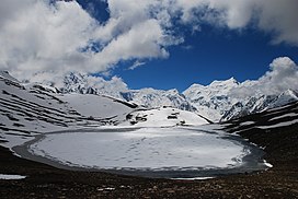
 Rush Lake below Rush Peak. Malubiting in the background. | |
| Highest point | |
| Elevation | 5,560 m (18,240 ft) |
| Coordinates | 36°10′14.3″N 74°53′23.1″E / 36.170639°N 74.889750°E[1] |
| Geography | |
| Location | Hispar, Pakistan |
| Parent range | Karakoram |
Rush Peak (Urdu: رش چوٹی) is a mountain in the Karakoram mountain range of Central Asia. It is located in the Nagar District of Gilgit-Baltistan, Pakistan. While not a high peak by local standards, it is noteworthy as a remote trekking destination. It can be reached via Nagar Valley and Hoper Village. The peak can be accessed via Hoper Glacier (Bualtar Glacier) and Barpu Glacier. The peak is relatively easy to climb in the summer months and ascents have been made by amateur climbers without proper mountaineering gear. In winter, access to the mountain is made difficult by heavy snow. The top of the peak provides views of Miar Peak (6,824 m), Miar Glacier and Phuparash Peak (6,574 m). On a clear day, one can look east of Rush Peak and see some of the world's highest mountains, including K2 and Broad Peak. At the mountain's base lies one of the world's highest alpine lakes, Rush Lake (4,694m).
See also
[edit]References
[edit]External links
[edit]

