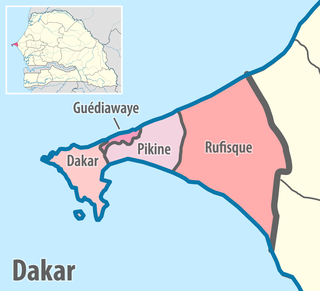
Rufisque Department
Appearance
This article needs additional citations for verification. (November 2016) |
Rufisque | |
|---|---|
 Location in the Dakar Region | |
| Country | |
| Region | Dakar Region |
| Capital | Rufisque |
| Area | |
• Total | 372 km2 (144 sq mi) |
| Population (2023 census) | |
• Total | 822,105 |
| • Density | 2,200/km2 (5,700/sq mi) |
| Time zone | UTC+0 (GMT) |
Rufisque Department is one of the 45 departments of Senegal and one of the four which make up the Dakar Region.
There are six urban communes within the department: Bargny, Sébikotane, Diamniadio, Jaxaay-Parcelle-Niakoul Rap, Sangalkam and Sendou. The rest of the department is divided into two arrondissements.
- Rufisque Arrondissement is subdivided into three communes de arrondissement: Rufisque Est, Rufisque Nord and Rufisque Ouest.
- Bambylor Arrondissement is subdivided into 3 rural districts (communautés rurales);
- Yéne
- Bambylor
- Tivaouane Peulh-Niaga

- The historic centre or Old Rufisque, lying between the East Canal, the West Canal, the railway line and the seafront.
- National printworks
- Former William Ponty school at Sébikotane
- Ancient dunes at Kounoune, Neolithic site
- Lake Retba, The Rose Lake or Pink Lake (coloured pink by algae)
References
[edit]14°43′01″N 17°16′01″W / 14.717°N 17.267°W
