Robin's Nest (Hong Kong)
| Robin's Nest | |
|---|---|
| 紅花嶺 | |
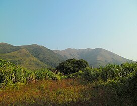
 Robin's Nest, as viewed from the Man Uk Pin Village near Sha Tau Kok. | |
| Highest point | |
| Elevation | 492 m (1,614 ft) |
| Coordinates | 22°32′29″N 114°11′24″E / 22.54139°N 114.19000°E |
| Geography | |
Eastern New Territories, Hong Kong | |
Robin's Nest (Chinese: 紅花嶺; Jyutping: Hung4 Faa1 Leng5 (former name:麻雀嶺)) is a hill located in Robin's Nest Country Park, northeastern Hong Kong, south of the border between Hong Kong and Shenzhen in the New Territories.[1] Robin's Nest is the 55th tallest hill in Hong Kong.
The name Hung Fa Leng (紅花嶺) does not translate directly as 'Robin's Nest' but as 'Red Flower Ridge'.
New Country Park
[edit]In 2017, the Hong Kong Government announced that it was planning to designate the area surrounding Robin's Nest as a country park, called Robin's Nest Country Park.[2] This proposed designation was made in June 2019.[3] As of 2021, the final legislative work on the designation is still in progress.[4] On March 1, 2024, Robin's Nest Country Park was officially established, becoming Hong Kong's 25th Country Park.[5]
See also
[edit]- Hung Fa Chai, a nearby hill
- List of mountains, peaks and hills in Hong Kong
- Ma Tseuk Leng (麻雀嶺), a nearby area and village, which has the same name as the former Chinese name of Robin's Nest
- Lin Ma Hang, a village with an old abandoned lead mine and MacIntosh Fort below Robin's Nest
References
[edit]- ^ "Hiking - Robins Nest, North East New Territories, Hong Kong". paddyinba.blogspot.com. Retrieved 2019-11-04.
- ^ "'Make Robin's Nest a country park right now'". RTHK. 21 May 2019.
- ^ Hui, Sophie (6 Jun 2019). "Robin's Nest wins country park designation". The Standard (Hong Kong). Retrieved 2020-10-17.
- ^ "紅花嶺郊野公園規劃工作緩慢 關注團體憂爛尾". on.cc東網 (in Chinese (Hong Kong)). 20 April 2021. Retrieved 2021-11-29.
- ^ "New country park established". Hong Kong's Information Services Department (in Chinese (Hong Kong)). Retrieved 2024-03-01.

