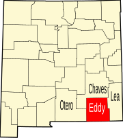
Riverside, Eddy County, New Mexico
Appearance
Riverside, New Mexico | |
|---|---|
| Coordinates: 32°50′10″N 104°18′38″W / 32.83611°N 104.31056°W | |
| Country | United States |
| State | New Mexico |
| List of counties in New Mexico | Eddy |
| Elevation | 3,332 ft (1,015 m) |
| Time zone | UTC-7 (MST) |
| • Summer (DST) | UTC-6 (MDT) |
| ZIP codes | 88210 |
| Area code | 575 |
Riverside is an unincorporated community in Eddy County, New Mexico, in the southwestern United States.[1] It is located on the left bank (east side) of the Pecos River about five miles east of Artesia, New Mexico on U.S. Route 82 (Lovington Highway).[2] Riverside is in the Loco Hills Division of Eddy County.[3]
The community of Riverside grew up in the 1970s as a place for oil workers' mobile homes and oil field support.[1] It was almost abandoned in the early 1980s, but came back in the 1990s as oil prices rose. Mack Energy Corporation has its corporate offices in Riverside.[4]
References
[edit]- ^ a b Julyan, Robert (1998). "Riverside (Eddy County)". The Place Names of New Mexico (revised ed.). Albuquerque, New Mexico: University of New Mexico Press. p. 300. ISBN 0-8263-1689-1.
- ^ Spring Lake Quadrangle, Eddy County, New Mexico (Map) (photorevised 1975 ed.). 1:24,000. 7.5 minutes series (topographic). United States Geological Survey. 1975.
- ^ "Loco Hills Division, NM Boundary Map". NM Hometown locator. Archived from the original on June 30, 2014.
- ^ "Mack Energy constructs new headquarters". Artesia News. May 6, 2010. Archived from the original on June 30, 2014.


