Riverbank, Ontario
Appearance
Riverbank | |
|---|---|
Unincorporated rural community | |
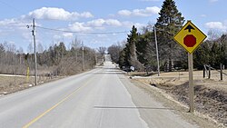
 Looking east on Concession Road 16 in Riverbank | |
| Coordinates: 43°49′11″N 80°37′26″W / 43.81972°N 80.62389°W | |
| Country | Canada |
| Province | Ontario |
| County | Wellington |
| Township | Mapleton |
| Time zone | UTC-5 (Eastern (EST)) |
| • Summer (DST) | UTC-4 (EDT) |
| GNBC Code | FENHW[1] |
Riverbank is an unincorporated rural community in Mapleton Township, Wellington County, Ontario, Canada.[1][2] Prior to 1999, Riverbank was located in Maryborough Township.[3]
The Conestogo River flows through Riverbank.
History
[edit]A post office was located in Riverbank from 1877 to 1915.[4]
The Riverbank Cheese and Butter Company was located at the settlement from 1882 to 1893.[5][6]
By 1910, Riverbank had a general store, and a daily stage to Drayton. The population was about 50.[7]
References
[edit]- ^ a b "Riverbank". Natural Resources Canada. October 6, 2016.
- ^ "Mapleton". Statistics Canada. November 2, 2016.
- ^ "Restructuring Flashnews Municipal Restructuring Summary Table". Ontario Ministry of Municipal Affairs. Retrieved April 25, 2017.
- ^ "Riverbank". Library and Archives Canada. May 27, 2014.
- ^ Sessional Papers - Legislature of the Province of Ontario. Vol. 7. Ontario Legislative Assembly. 1892. p. 53.
- ^ "Riverbank Cheese Factory". Wellington County Museum & Archives. Retrieved April 20, 2017.
- ^ Province of Ontario Gazetteer and Directory, 1910 - 1911. Union Publishing. 1911. p. 896.


