Repovesi National Park
| Repovesi National Park | |
|---|---|
 A summer night at Repovesi | |
| Location | Finland |
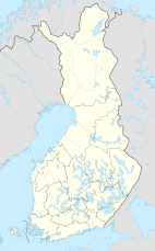
| Coordinates | 61°11′N 026°53′E / 61.183°N 26.883°E |
| Area | 15 km2 (5.8 sq mi) |
| Established | 2003 |
| Visitors | 74500 (in 2009[1]) |
| Governing body | Metsähallitus |
| Website | www |
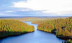
Repovesi National Park (Finnish: Repoveden kansallispuisto) is situated in the municipalities of Kouvola and Mäntyharju, only a few hours north-east of the more populous Helsinki area of southern Finland. Formerly a site for intensive commercial forestry, the Repovesi area successfully transformed into a pristine national park. Pine and birch trees dominate the park. Repovesi abounds with wildlife including bear, deer and various birds. The River Koukunjoki flows through the park. Other streams and lakes are also situated within the parks boundaries.

Attractions include the Olhavanvuori hill, popular among climbers, and the Kultareitti water taxi route. Also located in the park are the Kuutinlahti bay with its restored timber rafting channels, the Lapinsalmi suspension bridge, and many observation towers.
The common fauna of the park includes the red-throated diver, the Eurasian lynx, the moose, many owls and several galliformes.
See also
[edit]References
[edit]- ^ "Käyntimäärät kansallispuistoittain 2009" (in Finnish). Metsähallitus. Retrieved September 29, 2010.
External links
[edit] Media related to Repovesi National Park at Wikimedia Commons
- Outdoors.fi – Repovesi National Park
- Official site
- A gem of nature in southeastern Finland- Repovesi in thisisFINLAND

