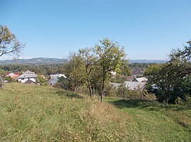
Remeți
Remeți
Ремета | |
|---|---|
 Remeți | |
 Location in Maramureș County | |
| Coordinates: 47°59′N 23°38′E / 47.983°N 23.633°E | |
| Country | Romania |
| County | Maramureș |
| Government | |
| • Mayor (2020–2024) | Ivan-Claudiu Brînzanic (UUR) |
Area | 63.4 km2 (24.5 sq mi) |
| Elevation | 231 m (758 ft) |
| Population (2021-12-01)[1] | 2,981 |
| • Density | 47/km2 (120/sq mi) |
| Time zone | EET/EEST (UTC+2/+3) |
| Postal code | 437235 |
| Area code | +(40) 262 |
| Vehicle reg. | MM |
| Website | comunaremeti |
Remeți (Ukrainian: Ремета; Rusyn: Ремети; Hungarian: Pálosremete; German: Remetz; Yiddish: רעמיק, romanized: Remit) is a commune in Maramureș County, Maramureș, Romania. It is composed of three villages: Piatra (Ukrainian: Каминиця; Hungarian: Kövesláz or Ferencvölgye), Remeți, and Teceu Mic (Тячів; Kistécső).
Geography
[edit]Remeți is located at the northwestern extremity of Maramureș County, 24 km (15 mi) from Sighetu Marmației and 58 km (36 mi) north of the county seat, Baia Mare, on the border with Satu Mare County and with Ukraine. The commune is situated in the eastern foothills of the Oaș Mountains, a mountain range which is part of the Inner Eastern Carpathians. The Huta Pass is 17 km (11 mi) to the southwest.
The Tisza River flows on the north side of Remeți, marking the Romania–Ukraine border; the city of Tiachiv lies across the river. The river Baia discharges into the Tisza in Remeți.
The commune is traversed by national road DN19, which starts in Oradea, runs through Satu Mare and Negrești-Oaș, traverses the Huta Pass, and ends in Sighetu Marmației.
Villages
[edit]The village of Piatra includes the hamlet of Valea lui Francisc, known in German as Franzenthal. This was among the places in Romania where Zipser Germans settled and spoke their dialect of Zipserisch.[2][3]
Demographics
[edit]| Year | Pop. | ±% |
|---|---|---|
| 1880 | 1,024 | — |
| 1900 | 1,259 | +22.9% |
| 1910 | 2,251 | +78.8% |
| 1930 | 2,544 | +13.0% |
| 1956 | 2,602 | +2.3% |
| 1977 | 3,003 | +15.4% |
| 1992 | 3,241 | +7.9% |
| 2002 | 3,058 | −5.6% |
| 2011 | 3,040 | −0.6% |
| 2021 | 2,981 | −1.9% |
| Source: Census data | ||
At the 2021 census, the commune had a population of 2,981, of which 70.14% were Ukrainians, 19.05% Romanians, 5.57% were Hungarians, and 1.31% Roma.[4]
References
[edit]- ^ "Populaţia rezidentă după grupa de vârstă, pe județe și municipii, orașe, comune, la 1 decembrie 2021" (XLS). National Institute of Statistics.
- ^ Claus Stephani, Volkserzählungen der Zipser in Nordrumänien (1983), p. 271: "So entstand Franzenthal (Valea lui Francisc), ein Weiler, der heute zur Gemeinde Remetz gehört und nach dem ersten Hüttenbesitzer, Graf Franz von Käroly, benannt worden ist." (Thus Franzenthal [Valea lui Francisc] arose, a hamlet which is today a part of the commune of Remetz [Remeți] and was named after the owner of the first huts there, Count Franz von Käroly.)
- ^ Hans Gehl, Interethnische Beziehungen im rumänisch-ungarisch-ukrainischen Kontaktraum vom 18. Jahrhundert bis zur Gegenwart (1999), p. 500: "[...] Teceul şi Piatra I (Valea lui Francisc) și Piatra II (Huța). [...] Piatra sau Huța - este un cătun care alături de Teceul Mic aparține de Remeți." (Teceu and Piatra I [Valea lui Francisc] and Piatra II [Huța]. Piatra or Huța - is a hamlet that together with Teceu Mic is part of Remeți.)
- ^ "Populația rezidentă după grupa de vârstă, pe județe și municipii, orașe, comune, la 1 decembrie 2021" (in Romanian). INSSE. 31 May 2023.
External links
[edit]


