Reimsbach
Reimsbach | |
|---|---|
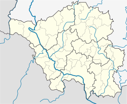
| Coordinates: 49°27′2″N 6°45′59″E / 49.45056°N 6.76639°E | |
| Country | Germany |
| State | Saarland |
| District | Merzig-Wadern |
| Municipality | Beckingen |
| Government | |
| • Local representative | Jürgen Dörholt |
| Area | |
• Total | 5.78 km2 (2.23 sq mi) |
| Elevation | 225 m (738 ft) |
| Population (2019)[1] | |
• Total | 1,970 |
| • Density | 340/km2 (880/sq mi) |
| Time zone | UTC+01:00 (CET) |
| • Summer (DST) | UTC+02:00 (CEST) |
| Postal codes | 66701 |
| Dialling codes | 06832 |
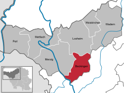
Reimsbach is a village (German: Ortsteil) in Germany and part of the Gemeinde Beckingen in the district ("Landkreis") of Merzig-Wadern (Saarland).[1]
History
[edit]The village was first mentioned in a document as "Rumestat" in 950 a.D. during the reign of archbishop Ruotbert.[1] Signs of Roman presence in the village centre were evidenced by a 1947 gold coin finding.
Next to the 1000-year old wild elm tree, on the outer rim of the village, a small chapel, endowed by Weidtmanns Wendel, is located. Named in honour of its benefactor, the Wendelinuskapelle was built in 1617 on a roman foundation.[2] The chapel survived artillery fire in the Thirty Years' War and the second World War as well as a fire in 1962.[2]
During the end of the second World War, Reimsbach was hit by 45 American bombs[3] as a result of an ammunition depot being near the village, killing nine inhabitants, injuring many more and dealing great damage to buildings, on 8 December 1944 at 15:50h local time, evidenced by the church clock stopping.[3]
Until 1973 Reimsbach was an independent district, before being incorporated into the newly formed Gemeinde Beckingen.[4] Since 1622 the village is known under its current name[5] and celebrated its 1050-year anniversary in mid-August 2000.[5] Further historical information can be found in Dorfchronik (1995) by Joseh Zehren (†)[3][6] and Bewegte Jahre (1994) by Volkmar Schommer,[7] whose neutrality is disputed[5] with Joseph Zehren being a contemporary witness.
Geography
[edit]Reimsbach is located on the one end of the Haustadter Tal, which encompasses Oppen, Reimsbach, Honzrath and Haustadt along the Mackenbach and Mühlenbach creeks. The climate is described as warm and moderate, but also wet for Continental Europe (Cfb) with an average temperature of 9.7 °C and about 730mm of precipitation.[8]
Catholic church St. Andreas
[edit]
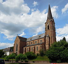
The catholic church St. Andreas was built from 1898 to 1901 by architect Wilhelm Hector from Sankt Johann (Saarbrücken),[9][10] who planned and constructed over fifty sacral buildings in the region, thus coining Historism and Neoclassicism achitectorial styles in the area now known as Saarland.[11]
External links
[edit]See also
[edit]Literature
[edit]- Volkmar Schommer (1994). Bewegte Jahre. Vol. I. Merzig/Düppenweiler: Merziger Druckerei und Verlag.
- Joseph Zehren (1995). Dorfchronik. Merzig: Merziger Druckerei und Verlag.
- Marschall, Kristine (2002). Sakralbauwerke des Klassizismus und des Historismus im Saarland. Saarbrücken: Institut für Landeskunde im Saarland. ISBN 978-3-923877-40-9.
References
[edit]- ^ a b c "Gemeindebezirk Reimsbach". Gemeinde Beckingen. Retrieved 23 September 2021.
- ^ a b "Wendelinuskapelle - Reimsbach". Pfarreiengemeinschaft Beckingen. Retrieved 28 May 2018.
- ^ a b c Zeitung, Saarbrücker. "Bilanz des Schreckens nach Bombenangriff auf Reimsbach". Saarbrücker Zeitung. Retrieved 27 May 2018.
- ^ Statistisches Bundesamt (1983). Historisches Gemeindeverzeichnis für die Bundesrepublik Deutschland. Namens-, Grenz- und Schlüsselnummernänderungen bei Gemeinden, Kreisen und Regierungsbezirken vom 27.5.1970 bis 31.12.1982. Stuttgart/Mainz: W. Kohlhammer. p. 804. ISBN 3170032631.
- ^ a b c "Geschichtliches". 28 June 2017. Archived from the original on 28 June 2017. Retrieved 27 May 2018.
- ^ Joseph Zehren (1995). Dorfchronik. Merzig: Merziger Druckerei und Verlag.
- ^ Volkmar Schommer (1994). Bewegte Jahre. Vol. I. Merzig/Düppenweiler: Merziger Druckerei und Verlag.
- ^ "Climate Beckingen: Temperature, Climograph, Climate table for Beckingen - Climate-Data.org". en.climate-data.org. Retrieved 28 May 2018.
- ^ Denkmalliste des Saarlandes, Teildenkmalliste Landkreis Merzig-Wadern (PDF; 285 kB), accessed 27 May 2018
- ^ Marschall, Kristine (2002). Sakralbauwerke des Klassizismus und des Historismus im Saarland. Saarbrücken: Institut für Landeskunde im Saarland. p. 666. ISBN 978-3-923877-40-9.
- ^ Hans-Berthold Busse, Peter Neumann (1989). Saarländische Lebensbilder. Vol. IV. Saarbrücken. pp. 131–154. ISBN 3925036202.
{{cite book}}: CS1 maint: location missing publisher (link)


