RAF Dounreay
Appearance
(Redirected from RNAS Dounreay)
RAF Dounreay | |
|---|---|
| Summary | |
| Airport type | Military |
| Operator | RAF, Royal Navy |
| Location | Dounreay |
| In use | 1944–1954 |
| Elevation AMSL | 112 ft / 34 m |
| Coordinates | 58°35′0″N 3°43′40″W / 58.58333°N 3.72778°W |
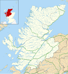
| Map | |
 | |
An editor has launched a copyright investigation involving this section. The text under investigation is currently hidden from public view, but is accessible in the page history. Please do not remove this notice or restore blanked content until the issue is resolved by an administrator, copyright clerk, or volunteer response agent.
The purported copyright violation copies text from https://web.archive.org/web/20220123173319/https://www.controltowers.co.uk/D/Dounreay.htm ; as such, this page has been listed on the copyright problems page. Unless the copyright status of the text of this page or section is clarified and determined to be compatible with Wikipedia's content license, the problematic text and revisions or the entire page may be deleted one week after the time of its listing (i.e. after 17:06, 16 November 2024 (UTC)). What can I do to resolve the issue?
Steps to list an article at Wikipedia:Copyright problems:
|
In 1955 the airfield was taken over by the United Kingdom Atomic Energy Authority (UKAEA) for developing a fast breeder reactor. One runway was kept operational until the 1990s for transport to/from the site.
See also
[edit]References
[edit]- ^ "ControlTowers.co.uk – Dounreay". Archived from the original on 23 January 2022. Retrieved 6 June 2009.
- Delve, Ken (2010). The Military Airfields of Britain: Scotland and Northern Ireland. Ramsbury, UK: The Crowood Press. ISBN 978-1-84797-027-5.
- Smith, David J. (1983). Action Stations: 7. Military airfields of Scotland, the North East and Northern Ireland. Cambridge: Patrick Stephens Limited. ISBN 0-85059-563-0.


