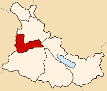
Quehue District
Appearance
Quehue
Q'iwi | |
|---|---|
 Location of Quehue in the Canas province | |
| Country | |
| Region | Cusco |
| Province | Canas |
| Founded | November 17, 1917 |
| Capital | Quehue |
| Government | |
| • Mayor | Hilario Callo Tapia (2007) |
| Area | |
| • Total | 143.46 km2 (55.39 sq mi) |
| Elevation | 3,792 m (12,441 ft) |
| Population | |
| • Total | 3,544 |
| • Density | 25/km2 (64/sq mi) |
| Time zone | UTC-5 (PET) |
| UBIGEO | 080507 |
Quehue (Aymara and Quechua: Q'iwi, meaning curve(d)) is one of eight districts in the Canas Province in Peru. Its seat is the village of Quehue.
Geography
[edit]One of the highest peaks of the district is Ch'iyar Jaqhi at 4,654 m (15,269 ft). Other mountains are listed below:[1]
- Ch'uwaña
- Luntuni
- Qullani Urqu
- Q'asa Saya
- Tuqtu
- Awki Tutukani
Ethnic groups
[edit]The people in the district are mainly indigenous citizens of Quechua descent. Quechua is the language which the majority of the population (97.36%) learnt to speak in childhood, 2.41% of the residents started speaking using the Spanish language (2007 Peru Census).[2]
See also
[edit]Sources
[edit]- ^ escale.minedu.gob.pe/ UGEL map Canas Province (Cusco Region)
- ^ inei.gob.pe Archived January 27, 2013, at the Wayback Machine INEI, Peru, Censos Nacionales 2007, Frequencias: Preguntas de Población
