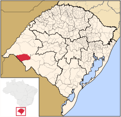
Quaraí
Quaraí | |
|---|---|
 Location in Rio Grande do Sul state | |
| Coordinates: 30°23′15″S 56°27′5″W / 30.38750°S 56.45139°W | |
| Country | Brazil |
| Region | South |
| State | Rio Grande do Sul |
| Mesoregion | Sudoeste Rio-Grandense |
| Microregion | Campanha Ocidental |
| Area | |
• Total | 3,147.63 km2 (1,215.31 sq mi) |
| Elevation | 112 m (367 ft) |
| Population (2020 [1]) | |
• Total | 22,607 |
| • Density | 7.2/km2 (19/sq mi) |
| Time zone | UTC−3 (BRT) |
| Postal code | 97560-xxx |
| Website | www |
Quarai is a Brazilian municipality located near the border with Uruguay on the Rio Quaraí. The population is 22,607 (2020 est.) in an area of 3,147.63 km2, making it one of the largest municipalities in the state.[2] Its elevation is 112 m. It is located 590 km west of the state capital of Porto Alegre, northeast of Montevideo, Uruguay and southeast of Alegrete.
Neighbouring municipalities
[edit]- Uruguaiana, north
- Rosário do Sul, east
- Santana do Livramento, south
- Artigas, Uruguay, south
- Alegrete, northwest
Flag
[edit]Created in 1971, the flag is made up of three stripes, blue, green and white in normal tones, it features a blue and red triangle-rectangle and a quadrilateral green that ascends between the two triangles with a blue triangle and in the left side of the flag, the angle of the green triangle is low and right. The center is elliptically vertical, in the white panel, the coat of arms added under law 400 December 21, 1964.
Geography
[edit]The area includes the Cerro do Jarau, a crater with 5.5 km in diameter dating back to around 117 million years and Salamanda do Jarau.
Population
[edit]| Year | Population |
|---|---|
| 1996 | 23,244 |
| 1997 | 23,430 |
| 1998 | 23,618 |
| 1999 | 23,809 |
| 2000 | 24,002 |
| 2004 | 24,987 |
| 2020 | 22,607 |
History
[edit]The first inhabitants were South American Indians including the Jarros, Guenoas, Minuanos and the Charruas people. The city was created on 8 April 1875.
The creation
[edit]The diplomatic action of the Treaty of Badajoz was signed in 1801 in which the then territorial boundary of Rio Grande do Sul became bounded at the Rio Quaraí. In 1814, its first ranches were founded.
Consular representation
[edit]Uruguay has a Consulate in Quaraí.[3]
Climate
[edit]| Climate data for Quaraí (1976–2005) | |||||||||||||
|---|---|---|---|---|---|---|---|---|---|---|---|---|---|
| Month | Jan | Feb | Mar | Apr | May | Jun | Jul | Aug | Sep | Oct | Nov | Dec | Year |
| Record high °C (°F) | 37.0 (98.6) |
35.7 (96.3) |
34.6 (94.3) |
31.3 (88.3) |
28.3 (82.9) |
26.3 (79.3) |
27.0 (80.6) |
29.0 (84.2) |
30.4 (86.7) |
33.0 (91.4) |
34.6 (94.3) |
36.3 (97.3) |
37.0 (98.6) |
| Mean daily maximum °C (°F) | 31.5 (88.7) |
30.1 (86.2) |
28.5 (83.3) |
24.6 (76.3) |
21.1 (70.0) |
18.3 (64.9) |
18.2 (64.8) |
20.2 (68.4) |
21.7 (71.1) |
24.7 (76.5) |
27.2 (81.0) |
30.3 (86.5) |
24.7 (76.5) |
| Daily mean °C (°F) | 25.5 (77.9) |
24.5 (76.1) |
23.0 (73.4) |
19.2 (66.6) |
15.9 (60.6) |
13.6 (56.5) |
13.5 (56.3) |
14.9 (58.8) |
16.3 (61.3) |
19.1 (66.4) |
21.3 (70.3) |
24.1 (75.4) |
19.2 (66.6) |
| Mean daily minimum °C (°F) | 19.5 (67.1) |
19.0 (66.2) |
17.6 (63.7) |
13.9 (57.0) |
10.8 (51.4) |
8.8 (47.8) |
8.8 (47.8) |
9.6 (49.3) |
10.8 (51.4) |
13.6 (56.5) |
15.4 (59.7) |
17.9 (64.2) |
13.8 (56.8) |
| Record low °C (°F) | 12.9 (55.2) |
12.2 (54.0) |
10.1 (50.2) |
5.4 (41.7) |
1.9 (35.4) |
−0.9 (30.4) |
−1.1 (30.0) |
0.6 (33.1) |
1.8 (35.2) |
5.2 (41.4) |
8.2 (46.8) |
10.9 (51.6) |
−1.1 (30.0) |
| Average precipitation mm (inches) | 132.5 (5.22) |
123.1 (4.85) |
133.6 (5.26) |
105.9 (4.17) |
107.5 (4.23) |
93.8 (3.69) |
92.5 (3.64) |
83.5 (3.29) |
117.6 (4.63) |
140.5 (5.53) |
93.6 (3.69) |
115.2 (4.54) |
1,339.3 (52.74) |
| Average relative humidity (%) | 66 | 70 | 75 | 77 | 81 | 80 | 80 | 76 | 71 | 70 | 67 | 64 | 73 |
| Mean monthly sunshine hours | 278 | 232 | 232 | 201 | 178 | 139 | 159 | 178 | 194 | 234 | 261 | 273 | 2,559 |
| Source: Empresa Brasileira de Pesquisa Agropecuária (EMBRAPA)[4] | |||||||||||||
See also
[edit]References
[edit]- ^ IBGE 2020
- ^ Instituto Brasileiro de Geografia e Estatística
- ^ "Directorio de oficinas consulares Uruguayas en el mundo". Ministerio de Relaciones Exteriores (in Spanish). Retrieved 13 October 2022.
- ^ "Atlas climático da Região Sul do Brasil: Estados do Paraná, Santa Catarina e Rio Grande do Sul" (PDF). EMBRAPA. Archived from the original (PDF) on 14 January 2024. Retrieved 25 May 2024.


