Esperança do Sul
Appearance
From Wikipedia, the free encyclopedia
Municipality in South, Brazil
Esperança do Sul | |
|---|---|
Municipality | |
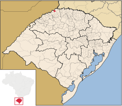
 Location of Esperança do Sul in Rio Grande do Sul | |
| Country | |
| Region | South |
| State | Rio Grande do Sul |
| Mesoregion | Noroeste Rio-Grandense |
| Microregion | Três Passos |
| Founded | 28 December 1995 |
| Government | |
| • Mayor | Moisés Alfredo Ledur (MDB, 2021 - 2024) |
| Area | |
| • Total | 148.909 km2 (57.494 sq mi) |
| Population (2021) | |
| • Total | 2,846 |
| • Density | 19/km2 (50/sq mi) |
| Demonym | Esperançulence |
| Time zone | UTC−3 (BRT) |
| Website | Official website |
Esperança do Sul is a municipality in the state of Rio Grande do Sul, Brazil. As of 2020, the estimated population was 2,885.[1]
The municipality would be partially flooded by the proposed Panambi Dam.[2]
See also
[edit]References
[edit]- ^ IBGE 2020
- ^ Eletrobras apresenta Garabi-Panambi a prefeitos (in Portuguese), Eletrobras CGTEE, 7 April 2014, retrieved 2016-11-11
27°21′18″S 53°59′31″W / 27.35500°S 53.99194°W / -27.35500; -53.99194
 | This geographical article relating to Rio Grande do Sul is a stub. You can help Wikipedia by expanding it. |


