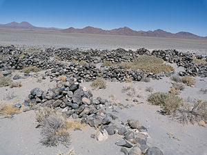
Pucará de Turi
 | |
 | |
| Type | Monumento histórico |
|---|---|
The Pucará de Turi an archaeological site in the locality of Turi, which is part of Calama, in the Antofagasta Region, Chile.[1][2][3] It is located 47 km northeast of the town of San Francisco de Chiu Chiu.
It is listed as a National Monument of Chile since 1983.[2][4]
History
[edit]
This pukara — Quechuan word meaning fortress or fortified hill—[3] is a Pre-Columbian stone construction located in the area of Turi. The fortified hamlet is located at an elevation of 3,100 m above sea level and occupies a surface area of approximately 4 ha.[2] It is the largest architectural complex built by the Atacama people.[2]
The construction dates back to c. 1250; while in the early 15th century, the Inca Topa Inca Yupanqui conquered the territory of the Atacama people, and approximately AD 1470, the citadel-like structure underwent a series of alterations by the addition of Incan structures,[5][6] including a Kallanka, a 26 metres (85 ft) long building covered with a gable roof.[7] The area included houses with rectangular plan measuring 4 m by 5 m.[8] The complex features about 620 enclosed areas of various sizes and shapes.[2]
References
[edit]- ^ Gallardo, F.; Vilches, F. (1995). Nota acerca de los estilos de arte rupestre en el Pucara de Turi (norte de Chile). Boletín de la Sociedad Chilena de Arqueología. pp. 26–28.
- ^ a b c d e "Pucará de Turi". Consejo de Monumentos Nacionales. Archived from the original on 10 November 2013. Retrieved 28 October 2013.
- ^ a b Imbelloni, José (1926). "Elementos lingüísticos de Oceanía en el Quechua". In Palavecino, E. (ed.). Palavecino (PDF). Buenos Aires: La Esfinge indiana, El Ateneo. pp. 335–349. Retrieved 30 October 2013.
- ^ "DS 36 MH Expresiones Urbanas Arquitectónicas de la región de Antofagasta". Santiago de Chile: Consejo de Monumentos Nacionales. 2 March 2009. Retrieved 13 October 2013.
- ^ Cruz, Nicolás; Vega, Alejandra; Aldunate del Solar, Carlos; Cereceda T., Pilar; Errázuriz K., Ana María (2005). Historia de Chile ilustrada. Zig-Zag. ISBN 978-956-121-696-9.
- ^ Berenguer Rodríguez, José (1997). Chile antes de Chile: Prehistoria. Museo Chileno de Arte Precolombino. p. 95.
- ^ Orellana Rodríguez, Mario (1994). Prehistoria y etnología de Chile. Ravo y Allende Editores. p. 240. ISBN 978-956-700-323-5.
- ^ "Pukara de Turi". protagonistasdelacultura.cl. Retrieved 10 November 2013.
