Pszczela Wola
Appearance
Pszczela Wola | |
|---|---|
Village | |
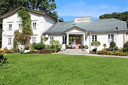
 Old manor house in Pszczela Wola | |
| Coordinates: 51°6′N 22°30′E / 51.100°N 22.500°E | |
| Country | |
| Voivodeship | Lublin |
| County | Lublin |
| Gmina | Strzyżewice |
| Population | |
• Total | 195 |
| Time zone | UTC+1 (CET) |
| • Summer (DST) | UTC+2 (CEST) |
| Vehicle registration | LUB |
Pszczela Wola [ˈpʂt͡ʂɛla ˈvɔla] is a village in the administrative district of Gmina Strzyżewice, within Lublin County, Lublin Voivodeship, in eastern Poland.[1] It lies approximately 18 km (11 mi) south of the regional capital Lublin.
References
[edit]

