Provo–Orem metropolitan area
Provo–Orem–Lehi, UT Metropolitan Statistical Area | |
|---|---|
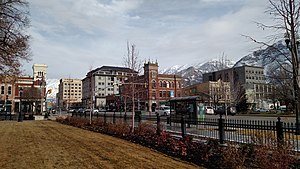
 Downtown Provo in January 2016 | |
 | |
| Country | |
| State | |
| Largest city | - Salt Lake City |
| Other principal cities |
|
| Area | |
• Total | 5,395.8 sq mi (13,975 km2) |
| Population | |
• Total | |
| • Density | 124.4/sq mi (48.0/km2) |
| GDP | |
| • Total | $40.761 billion (2022) |
| Time zone | UTC−7 (MST) |
| • Summer (DST) | UTC−6 (MDT) |
The Provo–Orem, UT Metropolitan Statistical Area, as defined by the United States Office of Management and Budget, is an area consisting of two counties in Utah, anchored by the cities of Provo and Orem. As of the 2020 census, the MSA had a population of 671,185.
Counties
[edit]Communities
[edit]- Alpine
- American Fork
- Benjamin (CDP)
- Birdseye (unincorporated)
- Bluffdale (partial)
- Callao (unincorporated)
- Cedar Fort
- Cedar Hills
- Draper (partial)
- Eagle Mountain
- Elberta (CDP)
- Elk Ridge
- Eureka
- Fairfield
- Genola
- Goshen
- Highland
- Juab (unincorporated)
- Lake Shore (CDP)
- Lehi
- Leland (unincorporated)
- Levan
- Lindon
- Mapleton
- Mills (unincorporated)
- Mona
- Nephi (county seat of Juab)
- Orem (Principal city)
- Palmyra (CDP)
- Partoun (unincorporated)
- Payson
- Pleasant Grove
- Provo (Principal city-Utah county seat)
- Rocky Ridge
- Salem
- Santaquin
- Saratoga Springs
- Spanish Fork
- Spring Lake (CDP)
- Springdell (unincorporated)
- Springville
- Trout Creek (unincorporated)
- Vineyard
- Vivian Park (unincorporated)
- West Mountain (CDP)
- Woodland Hills
- Former town site of Thistle
Demographics
[edit]| Census | Pop. | Note | %± |
|---|---|---|---|
| 2000 | 376,774 | — | |
| 2010 | 526,810 | 39.8% | |
| 2020 | 671,185 | 27.4% |
As of the census[2] of 2010, there were 526,810 people, 143,695 households, and 116,844 families residing within the MSA. The racial makeup of the MSA was 89.5% White, 0.5% African American, 0.6% Native American, 1.3% Asian, 0.7% Pacific Islander, 4.6% from other races, and 2.7% from two or more races. Hispanic or Latino of any race were 10.7% of the population.
As of the census of 2000, median income for a household in the MSA was $41,986, and the median income for a family was $46,426. Males had a median income of $35,750 versus $22,025 for females. The per capita income for the MSA was $14,174.
A survey of about 190 metropolitan areas found 77% of Provo-Orem residents are classified as "very religious," the largest percentage in the United States.[3]
See also
[edit]References
[edit]- ^ "Total Gross Domestic Product for Provo-Orem, UT (MSA)". fred.stlouisfed.org.
- ^ "U.S. Census website". United States Census Bureau. Retrieved 2008-01-31.
- ^ Survey: Provo-Orem area most religious in US. Usatoday.com (2013-03-30). Retrieved on 2013-07-21.
