Providenciales
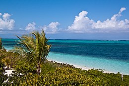
 Turtle Cove, Providenciales | |
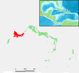
 Location of Providenciales within the Turks and Caicos Islands | |
| Geography | |
|---|---|
| Location | Atlantic Ocean |
| Coordinates | 21°46′39″N 72°15′44″W / 21.77750°N 72.26222°W |
| Archipelago | Lucayan Archipelago |
| Administration | |
United Kingdom | |
| British Overseas Territory | Turks and Caicos Islands |
| Demographics | |
| Population | 23,769 (2012)[1] |
| Additional information | |
| Time zone | |
| • Summer (DST) | |
| ISO code | TC |
Providenciales (known locally as Provo) is an island in the northwest Caicos Islands, part of the Turks and Caicos Islands, a British Overseas Territory.[2] The island has an area of 98 km2 (38 sq mi) and a 2012 Census population of 23,769.[1] Providenciales is the third largest island in the Turks and Caicos in area, and is home to a large majority of the population of the Turks and Caicos Islands.[3]
Transportation
[edit]

The island is served by the Providenciales International Airport.[4]
There is no public transportation on the island.[5]
As recently as 1964, Providenciales did not have a single wheeled vehicle. Roads, water, telephones, and electricity were also absent. The original developer, Provident, Ltd, had shuttle flights from Florida (for a real estate buying program) two times a week in a World War II DC-3 plane and the only hotel was the Third Turtle Inn built by them in 1967.[6]
Economy
[edit]Providenciales is the most tourist-oriented and developed of the Turks and Caicos Islands, boasting many resort hotels and an 18-hole golf course.[3] The island has recently become popular with retirees from around the world, kindling a boom of residential development. Grace Bay has seen many luxury condos built on its shores.[citation needed]
Visitor attractions
[edit]The island is close to a common migration route for the humpback whale. Providenciales is surrounded by uninhabited cays that are easily reached by chartered boat or excursion.
The resorts on Providenciales are primarily centred on 5 mi (8 km) long Grace Bay. Apart from the beaches, the island's charm lies in its rugged hills and ridges, which are carpeted with prickly pear cactus and scrub.[7]
Long Bay Beach, on the southern, windward side of the island is still largely undeveloped save for a large luxury resort on the northern tip of the beach. Due to its steady wind and relatively isolated location, Long Bay Beach is rapidly becoming a kiteboarding destination in the Caribbean.[8]
There are remnants of Caribbean piracy at Osprey Rock and Sapodilla Hill, and the ruins of Cheshire Hall plantation, a sisal and cotton plantation owned by the British Loyalist, Thomas Stubbs from the 1790s until 1810.[9]
Ecology
[edit]
The western half of Providenciales is mostly barren wilderness,[3] home to the island's best natural attraction, Chalk Sound National Park. The park is a 3 mi (5 km) long bay southwest of Downtown. The colour of the water is a uniform turquoise and studded with countless mushroom-like tiny islets.[10] Also on the western part of the island is Northwest Point Marine National Park, which extends to nearby reefs and several saline lakes that attract breeding and migrant waterfowl.[3]
Towns
[edit]The major road, the Leeward Highway, runs east–west from Downtown to Leeward. Most of the island's services are near the Highway, including shopping plazas.
The communities of Downtown and Kew Town are located near Providenciales International Airport. The town of Wheeland is in the northwest corner of the island.
Before Provo became a popular tourist destination, there were three small centers of population: Blue Hills, The Bight (on Grace Bay) and Five Cays. Now many houses have been built, predominantly in the east and south, with larger communities at Leeward, Long Bay and Chalk Sound, as well as expansion of the original three settlements. There are also pockets of makeshift shacks interspersed among the more upscale residences.[citation needed]
Education
[edit]Clement Howell High School and Long Bay High School are the local public high schools.[11]
International School of the Turks and Caicos Islands, which serves preschool through grade six, is also in Providenciales, in Leeward. In 2014 it had 106 students. It was known as The Ashcroft School until 2014.[12]
Images
[edit]References
[edit]- ^ a b "Population 2012 census". Government of Turks and Caicos. Retrieved 15 May 2021.
- ^ "Turks and Caicos Islands". UK Overseas Territories Conservation Forum. Retrieved 2019-05-04.
- ^ a b c d Murray, Lorraine (August 10, 2015). "Providenciales". Encyclopædia Britannica. Encyclopædia Britannica, inc. Retrieved May 4, 2019.
- ^ "Getting to Providenciales". Visit Turks and Caicos Islands. Retrieved 2019-05-03.
- ^ "Getting Around Providenciales". Visit Turks and Caicos Islands. Retrieved 2019-05-03.
- ^ Discover Magazine 2014 "Turks & Caicos | discover. Your destinationTurks & Caicos | discover. Your destination". Archived from the original on 2014-11-21. Retrieved 2014-11-22.
- ^ "Turks and Caicos Islands". Encyclopædia Britannica. Encyclopædia Britannica, inc. January 31, 2019. Retrieved May 4, 2019.
- ^ "Photos of Kiteboarding and Windsurfing on Long Bay Beach". 12 July 2010. Retrieved 12 July 2015.
- ^ LeVin, Daniel J. "Cheshire Hall Plantation". www.visittci.com. Retrieved 13 March 2022.
- ^ "Turks and Caicos Islands". Travellers Point. Retrieved 16 August 2024.
- ^ "Schools". Government of Turks and Caicos. Retrieved 15 May 2021.
- ^ Tyson, Vivian (2014-09-15). "Ashcroft School is now International School of the TCI". The Sun. Retrieved 2020-01-18.


