Prinsenland
Appearance
This article needs additional citations for verification. (May 2021) |
Prinsenland | |
|---|---|
Neighborhood of Rotterdam | |
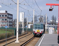
 Metrostation Schenkel | |
 | |
| Country | |
| Province | South Holland |
| COROP | Rotterdam |
| Borough | Prins Alexander |
| Time zone | UTC+1 (CET) |
Prinsenland is a neighborhood of Rotterdam, Netherlands.
51°56′4″N 4°32′55″E / 51.93444°N 4.54861°EThe north of the neighborhood was built in the 1960s, at the same time as the adjacent neighborhood Het Lage Land. The rest of the neighborhood was built in several stages in the 1990s.
It consists of many different types of housing (flats, apartments, row-houses) surrounding the urban park Prinsenpark.[1] In the Prinsenpark there is a cemetery, skate park, and a lake, which contains the monument to the lowest point in the Netherlands, the Vierkant eiland in de plas (Square Island in the Lake) build in 1996.[2]
References
[edit]- ^ "Het Lage Land". 1 October 2017. Archived from the original on 2017-10-01. Retrieved 24 March 2024.
- ^ "Dutch Water Facts". www.holland.com. 2011-05-31. Retrieved 2021-05-14.
