Porterfield (community), Wisconsin
Porterfield, Wisconsin | |
|---|---|
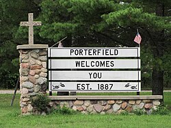
 Porterfield welcome sign on Church Street | |
| Coordinates: 45°09′16″N 87°47′40″W / 45.15444°N 87.79444°W | |
| Country | |
| State | |
| County | Marinette |
| Elevation | 203 m (666 ft) |
| Time zone | UTC-6 (Central (CST)) |
| • Summer (DST) | UTC-5 (CDT) |
| ZIP code | 54159 |
| Area code(s) | 715 & 534 |
| GNIS feature ID | 1571805[1] |
Porterfield is a census-designated place in the town of Porterfield, Marinette County, Wisconsin, United States.

Geography
[edit]Porterfield is located along the Escanaba and Lake Superior Railroad 9 miles (14 km) west-northwest of Marinette.[2] Porterfield has a post office with ZIP code 54159.[3] The Peshtigo River runs south of the community.[4]
History
[edit]Porterfield developed as a railroad junction,[4] and it was named after a local farmer and businessman, John Porterfield.[5][6] A post office was established in Porterfield in 1885.[7] In the past, Porterfield had an apartment house (a former grocery store), a bar, a blacksmith shop, and a cheese factory.[4]
School
[edit]
Before a new elementary school was built in Porterfield in 1963,[8] the area was served by several small schools: Miles School and Winesville School to the north, Dickie School and Fairmont School to the northwest, Fairdale School to the southwest, Phillips School, Plumb School, and Sandberg School to the south, Stewart School to the southeast, and Redelings School to the east.[9][10][11] The old county school buildings were sold off in 1963.[12] Porterfield Elementary School was part of the School District of Marinette[4] and served approximately 120 students.[13] The elementary school was closed at the end of the 2006–2007 school year.[14][15][16][17]
See also
[edit]References
[edit]- ^ U.S. Geological Survey Geographic Names Information System: Porterfield (community), Wisconsin
- ^ Marinette County (PDF) (Map). Wisconsin Department of Transportation. Archived from the original (PDF) on June 14, 2011. Retrieved December 17, 2010.
- ^ ZIP Code Lookup
- ^ a b c d "Peshtigo Runs past Porterfield". Green Bay Press-Gazette. May 21, 1975. p. 52. Retrieved July 31, 2019 – via Newspapers.com.

- ^ Gard, Robert E. (2016). The Romance of Wisconsin Place Names. Madison, WI: Wisconsin Historical Society Press. p. 266.
- ^ Marinette County, Wisconsin
- ^ "Wisconsin. Marinette County". Jim Forte Postal History. Retrieved August 2, 2019.
- ^ "Sept. 3 Starting Date for Marinette Students". Green Bay Press-Gazette. August 24, 1963. p. 7. Retrieved August 4, 2019 – via Newspapers.com.

- ^ Wisconsin: Porterfield Quadrangle, 15-Minute Series. 1939. Map, 1:48,000. Washington, DC: United States Department of the Interior Geological Survey.
- ^ Wisconsin: Marinette Quadrangle, 15-Minute Series. 1939. Map, 1:48,000. Washington, DC: United States Department of the Interior Geological Survey.
- ^ "Vaccination Plan in Marinette Co". Green Bay Press-Gazette. October 1, 1938. p. 4. Retrieved August 4, 2019 – via Newspapers.com.

- ^ "Marinette School Board Reviews Policy on Age of Kindergartens". Green Bay Press-Gazette. September 11, 1963. p. 16. Retrieved August 4, 2019 – via Newspapers.com.

- ^ Vierbicher Associates, Inc. 2003. Town of Porterfield Comprehensive Plan
- ^ "Fight to Keep Porterfield School Open Continues." Marinette & Menominee Eagle-Herald, 27 March 2007, page A1.
- ^ "School Board Votes to Close Porterfield School." Marinette & Menominee Eagle-Herald, 8 May 2007, page A1.
- ^ 2007-2008 Wisconsin Legislature. Assembly Bill 441.
- ^ Desotell, Mike (April 11, 2013). "School Board Contemplates Reopening Menekaunee School" (PDF). Marinette-Menominee Eagle Herald. p. 1. Retrieved July 31, 2019.
External links
[edit]![]() Media related to Porterfield (community), Wisconsin at Wikimedia Commons
Media related to Porterfield (community), Wisconsin at Wikimedia Commons


