Portal:San Francisco Bay Area
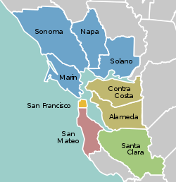
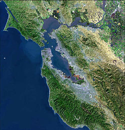
The San Francisco Bay Area Portal  The San Francisco Bay Area (referred to locally as the Bay Area) is a populous region surrounding the San Francisco and San Pablo estuaries in Northern California. The region encompasses the major cities and metropolitan areas of San Jose, San Francisco, and Oakland, along with smaller urban and rural areas. The Bay Area's nine counties are Alameda, Contra Costa, Marin, Napa, San Francisco, San Mateo, Santa Clara, Solano, and Sonoma. Home to approximately 7.68 million people, the nine-county Bay Area contains many cities, towns, airports, and associated regional, state, and national parks, connected by a network of roads, highways, railroads, bridges, tunnels, and commuter rail. The combined statistical area of the region is the second-largest in California (after the Greater Los Angeles area), the fifth-largest in the United States, and the 43rd-largest urban area in the world with 8.80 million people. The Bay Area has the second-most Fortune 500 companies in the United States, after the New York metropolitan area, and is known for its natural beauty, liberal politics, entrepreneurship, and diversity. The area ranks second in highest density of college graduates, after the Washington, D.C. metropolitan area and performs above the state median household income in the 2010 census; it includes the five highest California counties by per capita income and two of the top 25 wealthiest counties in the United States. Based on a 2013 population report from the California Department of Finance, the Bay Area is the only region in California where the rate of people migrating in from other areas in the United States is greater than the rate of those leaving the region, led by Alameda and Contra Costa counties. (more...) Selected article The Alcatraz Federal Penitentiary or United States Penitentiary, Alcatraz Island (often just referred to as Alcatraz) was a maximum high security Federal prison on Alcatraz Island, off the coast of San Francisco, California, USA, which operated from 1934 to 1963. The main prison building was built in 1910-12 during the time it was a United States Army military prison; Alcatraz was the site of a citadel from the 1860s. The United States Disciplinary Barracks on Alcatraz was acquired by the United States Department of Justice on October 12, 1933, and the island became a Federal Bureau of Prisons federal prison in August 1934, after the buildings were modernized to meet the requirements of a top-notch security prison. Given this high security and the location of Alcatraz in the cold waters and strong currents of San Francisco Bay, at least a mile off the coast, the prison operators believed Alcatraz to be inescapable and America's strongest prison. (more...) Selected biography Born in Brooklyn, New York, Boxer graduated from Brooklyn College. She worked as a stockbroker for several years before moving to California with her husband. During the 1970s, she worked as a journalist for the Pacific Sun and as an aide to U.S. Representative John L. Burton. She served on the Marin County Board of Supervisors for six years and became the board's first female president. With the slogan "Barbara Boxer Gives a Damn", she was elected to the United States House of Representatives in 1982, representing California District 6. She sat on the House Armed Services Committee, and was involved in government oversight, passing several procurement reforms. Boxer won the 1992 election for the U.S. Senate. She previously held the record for the most popular votes in any U.S. Senate election in history, having received 6.96 million votes in her 2004 re-election, until her colleague, Dianne Feinstein, the senior Senator from California, surpassed that number in her 2012 re-election. Boxer is the chair of the Environment and Public Works Committee and the chair of the Select Committee on Ethics, making her the only senator to preside over two committees simultaneously. She is also the Democratic Chief Deputy Whip. She resides in Marin County. (more...) Selected city Walnut Creek is a city in Contra Costa County, California, United States, located in the East Bay region of the San Francisco Bay Area. With a total estimated population of 67,673, Walnut Creek serves as a hub for its neighboring cities because of its location at the junction of the highways from Sacramento and San Jose (I-680) and San Francisco/Oakland (SR-24) and its accessibility by BART. Its active downtown neighborhood features hundred-year-old buildings and extensive high-end retail establishments, restaurants and entertainment venues. Walnut Creek owns more open space per capita than any other community in the state of California. In 1974, Walnut Creek voters approved a $6.7 million bond measure that allowed the city to purchase 1,800 acres (730 ha) of undeveloped hillsides, ridge lines, and park sites. Walnut Creek owns parts of Lime Ridge Open Space, Shell Ridge Open Space, Acalanes Ridge Open Space, and Sugarloaf Open Space. (more...) Selected image
The Bay Area by year1988

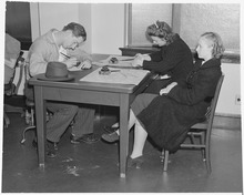
Selected historical imageDid you know...
Previous Did you know... 
Selected periodic event The Festival del Sole is an annual ten-day jazz and classical music, food, wine, and art festival held in Napa Valley. Founded in 2006 by Richard Walker and Barrett Wissman, the festival attracts over 8,000 attendees annually. Performers at the festival have included Monica Mancini, Pinchas Zukerman, Dmitry Sitkovetsky and Arturo Sandoval (pictured, at a White House performance). Quote
Selected multimedia file1898 launch of the Imperial Japanese Navy cruiser Chitose , filmed by Thomas Edison Co. credit: Library of Congress
Bay Area regions, geographic features and protected areasRelated PortalsWikiProject
Things you can do *Write an article on a Bay Area-related subject Selected panorama Crissy Field beach on San Francisco Bay in San Francisco, with the Golden Gate Bridge obscured by San Francisco fog
image credit: Brocken Inaglory
San Francisco Bay Area categoriesBay Area | San Francisco Bay | San Francisco | San Jose | Oakland | Cities | Census-designated places | Historic Places | National Landmarks | Counties: Alameda | Contra Costa | Marin | Napa | San Mateo | Santa Clara | Solano | Sonoma
Architecture | Attractions | Books | Culture | Economy | Education | Environment | Events & Festivals | Geography | Government | History | Landmarks | Law | Mass media | Military | Music | Organizations | Parks | People | Politics | Science | Sports | Transport
Full category tree
Select [►] to view the full category tree.
Associated WikimediaThe following Wikimedia Foundation sister projects provide more on this subject:
Discover Wikipedia using portals |
- All portals
- San Francisco Bay Area portal
- San Francisco Bay Area portal selected article pages
- San Francisco Bay Area portal selected biography pages
- San Francisco Bay Area portal selected city pages
- San Francisco Bay Area portal selected picture pages
- San Francisco Bay Area portal years pages
- San Francisco Bay Area portal selected historical image pages
- San Francisco Bay Area portal did you know pages
- San Francisco Bay Area portal festivals pages
- San Francisco Bay Area portal quotes pages
- San Francisco Bay Area portal selected multimedia pages
- San Francisco Bay Area portal selected panorama pages
- California portals
- San Francisco Bay Area
- United States portals by city


