Portal:Iceland/Selected picture
Usage
The template used to format these sub-pages is located at {{selected picture}}.
- Add a new selected picture to the next available subpage.
- Update "max=" to new total for its
{{Random portal component}}on the main page.
Selected picture 1
Portal:Iceland/Selected picture/1

Gullfoss is a waterfall located on the Hvítá in south central Iceland. Its name means the "Golden Falls." The flow of the river from the regular rains and the glacial runoff, particularly in summer, makes Gullfoss the largest volume falls in Europe.
Selected picture 2
Portal:Iceland/Selected picture/2

Mývatn is a shallow eutrophic lake situated in an area of active volcanism in the north of Iceland, not far from Krafla volcano. The lake and its surrounding wetlands have an exceptionally rich fauna of waterbirds, especially ducks. The lake was created by a large basaltic lava eruption 2300 years ago, and the surrounding landscape is dominated by volcanic landforms (pictured), including lava pillars and pseudocraters. The effluent river Laxá is known for its rich fishing for Brown Trout and Atlantic Salmon.
Selected picture 3
Portal:Iceland/Selected picture/3

Jökulsárlón is a glacial lake in Iceland. To the right is the mouth of the Vatnajökull, the largest glacier in Iceland.
Selected picture 4
Portal:Iceland/Selected picture/4
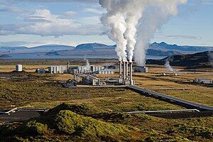
The Nesjavellir Geothermal Power Station services the Capital Region's hot water needs. Virtually all of Iceland's electricity comes from renewable resources.
Selected picture 5
Portal:Iceland/Selected picture/5

The image shows the only part of the crater of the volcano Grímsvötn in Iceland not covered by the ice of Vatnajökull glacier in 1972.
Selected picture 6
Portal:Iceland/Selected picture/6

The Dettifoss is a waterfall located in northeastern Iceland, not far from Mývatn. It is reputed to be the most powerful waterfall in Europe, having a flow variously estimated at between 200 and 500 cubic metres of water per second, depending on the season and the summer ice melt.
Selected picture 7
Portal:Iceland/Selected picture/7

The Icelandic horse is a breed of horse that has lived in Iceland since the mid-800s, brought to the island by Viking settlers. It originated from pony breeds taken from Scandinavian and European countries to Iceland during the original and subsequent settlements but has now been bred for centuries without the addition of outside bloodstock.
Selected picture 8
Portal:Iceland/Selected picture/8

Strokkur (meaning churn) is a geyser in the geothermic region beside the Hvítá River. The geyser is only a few meters away from Geysir.
Selected picture 9
Portal:Iceland/Selected picture/9
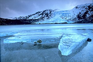
Eyjafjallajökull is one of the smaller Icelandic glaciers, located north of Skógar and west of the larger glacier Mýrdalsjökull. The ice cap of the glacier covers a volcano, which has erupted relatively frequently since the Ice Age. The last eruption was from 1821 to 1823, causing a fatal glacier run. The crater of the volcano has a diameter of 3-4 km and the glacier covers an area of about 100 km².
Selected picture 10
Portal:Iceland/Selected picture/10
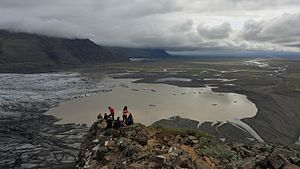
Skaftafell is an national park in South Iceland, which was founded on 15 September 1967. It was merged into Vatnajökull national park, on its creation on 8 June 2008. This picture is of Skaftafellsjökull, one of the glaciers of Vatnajökull.
Selected picture 11
Portal:Iceland/Selected picture/11
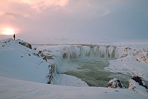
The Goðafoss (meaning waterfall of the gods), situated in north-central Iceland, is one of the country's most spectacular waterfalls. The water of the river Skjálfandafljót falls from a height of 12 meters over a width of 30 meters.
Selected picture 12
Portal:Iceland/Selected picture/12
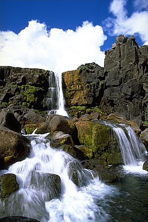
Öxarárfoss is a small waterfall in and one of the main attractions of Þingvellir National Park, Iceland. It flows from the river Öxará. The base of the waterfall is filled with rocks and is often very icy in winter.
Selected picture 13
Portal:Iceland/Selected picture/13
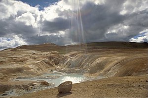
Around the volcano Leirhnjúkur in Iceland, there are several hot springs. These springs are produced by the emergence of geothermally-heated groundwater from the earth's crust. Iceland is particularly renowned for its hot springs.
Selected picture 14
Portal:Iceland/Selected picture/14

Fimmvörðuháls is an pass between the glaciers Eyjafjallajökull and Mýrdalsjökull in South-Iceland. In 2010 there was an fissure eruption, originating from Eyjafjallajökull. This picture is of said eruption.
Selected picture 15
Portal:Iceland/Selected picture/15

The atlantic puffin is a seabird. 60% of the worldwide atlantic puffin population is found in Iceland, the rest can be found in Norway, Greenland, Newfoundland and North Atlantic islands.
Selected picture 16
Portal:Iceland/Selected picture/16

Selfoss is a waterfall in Northern Iceland. It flows from the glacial river Jökulsá á Fjöllum, which originates from the glacier Vatnajökull.
Selected picture 17
Portal:Iceland/Selected picture/17
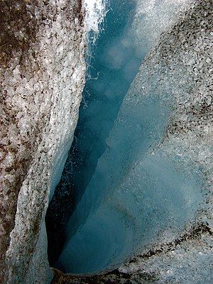
Langjökull is an glacier in central Iceland. It is the second largest glacier in Iceland after Vatnajökull. This picture is of an crevasse in the glacier, three to four meters long, meter wide and 30-40 meters deep.
Selected picture 18
Portal:Iceland/Selected picture/18

Elliðaey is an island in South Iceland. It is part of the Vestmannaeyjar island cluster, and is the third largest of those islands. The island is unhabited, but puffins are hunted on the island during summer.
Selected picture 19
Portal:Iceland/Selected picture/19

Reynisfjara is an black beach in South Iceland, close to the town Vík í Mýrdal. Outside of the beach are basalt sea stacks, named Reynisdrangar. The beach was voted in 1991 as one of the ten most beautiful non-tropical beaches in the world.[1] The beach is dangerous, though, as large rocks have collapsed into the beach in August 2019.
Selected picture 20
Portal:Iceland/Selected picture/20

Vestmannaeyjar is an cluster of islands in South Iceland. On the main island, Heimaey is the town Vestmannaeyjabær. This picture is of the harbour of the town. This harbour was under threat of being closed off in an eruption on the 23 January 1973. Water was sprayed onto the lava to prevent the harbor from being closed off.
Selected picture 21
Portal:Iceland/Selected picture/21

Dyrhólaey is an promonotory in South Iceland. It features an gigantic arch of rock onto a pillar in the sea. It used to be the most southern tip of Iceland, until Katla erupted in 1918. Since then the peninsula Kötlutangi is the most southern point.
Nominations
Feel free to add any featured pictures to the list above. You can also nominate other pictures relating to Iceland here.
