Port of Pori
| Port of Pori | |
|---|---|
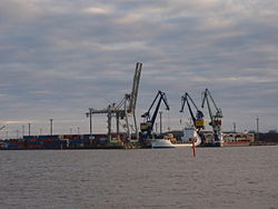
 Mäntyluoto harbour | |
 Click on the map for a fullscreen view | |
| Location | |
| Country | Finland |
| Coordinates | 61°35′N 21°29′E / 61.583°N 21.483°E |
| UN/LOCODE | FIPOR[1][2] |
| Details | |
| No. of berths | 23[2] |
| Draft depth | 15.3m[2] |
| Statistics | |
| Website www | |
Port of Pori (Finnish: Porin satama) is a complex of three harbours. It is by the Gulf of Bothnia in Pori, Finland. The port authority of Pori was established in 1780. Today the Port of Pori is a corporation owned by the city.
Port of Pori has liner service to several ports in Northern Europe, for example Hamburg, Ghent, St. Petersburg and Teesport.
Mäntyluoto
[edit]Mäntyluoto harbour has docks for container traffic and dry bulk. Crane capacity is up to 200 tonnes (200 long tons; 220 short tons). The 200-ton crane Masa is the strongest in Finnish ports. The maximum allowed draught in Mäntyluoto is 12.0 metres (39.4 ft).
Tahkoluoto
[edit]The Tahkoluoto bulk harbour has 15.3-metre (50 ft) draught which allows access for capesize vessels.[2] Oil and chemical harbour operates in a separate area.
See also
[edit]References
[edit]- ^ "UNLOCODE (FI) - FINLAND". service.unece.org. Retrieved 19 February 2021.
- ^ a b c d "Port of Pori, Finland". www.findaport.com. Shipping Guides Ltd. Retrieved 19 February 2021.
External links
[edit]![]() Media related to Port of Pori at Wikimedia Commons
Media related to Port of Pori at Wikimedia Commons
