Port de Cabús
Appearance
| Port de Cabús | |
|---|---|
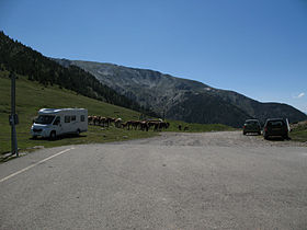
 End of the CG-4 road at Port de Cabús | |
| Elevation | 2302 m[1] |
| Location | La Massana, Andorra Alins, Spain |
| Range | Pyrenees |
| Coordinates | 42°32′47″N 1°25′11″E / 42.54639°N 1.41972°E |
Port de Cabús (el. 2302 m.) is a mountain pass in the Pyrenees on the Andorran-Spanish border connecting the parish of La Massana with Alins, in Catalonia, Spain. The road is paved on the Andorran side, but not on the Spanish side.[2]
The pass is a legal anomaly in that there are no border controls there, despite it forming the outer border of the Schengen Area, which usually features robust passport checks.
See also
[edit]External links
[edit]References
[edit]- ^ Rutes Ciclistes d'Andorra - Ruta 9, Erts-Port de Cabús
- ^ Xavier Basora; Jordi Romero; Xavier Sabaté (31 December 2005). "MUNTANYA DE TOR". territori.scot.cat (in Catalan). Societat Catalana d’Ordenació del Territori. Retrieved 20 July 2012.

