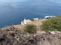
Ponta Preta Lighthouse
Appearance
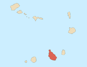
 Ponta Preta Lighthouse in the northwesternmost area of Santiago Island | |
 | |
| Location | Tarrafal Santiago Cape Verde |
|---|---|
| Coordinates | 15°17′34.4″N 23°46′16.4″W / 15.292889°N 23.771222°W |
| Tower | |
| Constructed | 1889 |
| Foundation | masonry base |
| Construction | metal post |
| Height | 6 metres (20 ft)[1] |
| Shape | post light atop a pyramidal base |
| Markings | white post and base |
| Light | |
| Focal height | 34 metres (112 ft)[1] |
| Range | 8 nautical miles (15 km; 9.2 mi)[1] |
| Characteristic | Fl (3) W 12s.[1] |
| Cape Verde no. | PT-2148[2] |
Farol da Ponta Preta (the Ponta Preta Lighthouse) is a lighthouse on the northwesternmost part of the island of Santiago, Cape Verde. It stands on the headland Ponta Preta, 3 km northwest of the city Tarrafal. The lighthouse was constructed in 1889. Its lantern stands on a white column with a pyramidal base, in front of a small one storey building.[2] The lighthouse was depicted on a Cape Verdean stamp in 2004.[3]
See also
[edit]Gallery
[edit]-
Ponta Preta Lighthouse from the southeastern side of the bay
-
Ponta Preta Lighthouse above the nearby hill
References
[edit]- ^ a b c d List of Lights, Pub. 113: The West Coasts of Europe and Africa, the Mediterranean Sea, Black Sea and Azovskoye More (Sea of Azov) (PDF). List of Lights. United States National Geospatial-Intelligence Agency. 2015.
- ^ a b Rowlett, Russ. "Lighthouses of Cape Verde". The Lighthouse Directory. University of North Carolina at Chapel Hill.
- ^ Photo of a Cape Verdean stamp at the Lighthouse Stamp Society.
External links
[edit] Media related to Farol da Ponta Preta at Wikimedia Commons


