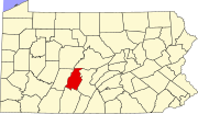
Point View, Pennsylvania
Point View, Pennsylvania | |
|---|---|
| Coordinates: 40°29′22″N 78°14′31″W / 40.48944°N 78.24194°W | |
| Country | United States |
| State | Pennsylvania |
| County | Blair |
| Township | Catharine |
| Area | |
| • Total | 0.02 sq mi (0.05 km2) |
| • Land | 0.02 sq mi (0.05 km2) |
| • Water | 0.00 sq mi (0.00 km2) |
| Elevation | 961 ft (293 m) |
| Population | |
| • Total | 14 |
| • Density | 700.00/sq mi (264.65/km2) |
| Time zone | UTC-5 (Eastern (EST)) |
| • Summer (DST) | UTC-4 (EDT) |
| ZIP Code | 16693 (Williamsburg) |
| Area code(s) | 814/582 |
| FIPS code | 42-61888 |
| GNIS feature ID | 2805543[2] |
Point View is an unincorporated community and census-designated place (CDP) in Blair County, Pennsylvania, United States. It was first listed as a CDP prior to the 2020 census.[2]
The CDP is in eastern Blair County, along the southwestern edge of Catharine Township. It is in the valley of Township Run, which forms the boundary between Catharine and Frankstown Township. The small, steep valley is between Short Mountain to the east and the south end of Canoe Mountain to the west, and drains south to the Frankstown Branch of the Juniata River. Pennsylvania Route 866 is the southern edge of the CDP; the highway leads southeast down the Frankstown Branch 3 miles (5 km) to Williamsburg and west 0.5 miles (0.8 km) to U.S. Route 22, which continues west 9 miles (14 km) to Hollidaysburg, the Blair county seat.
Demographics
[edit]| Census | Pop. | Note | %± |
|---|---|---|---|
| 2020 | 14 | — | |
| U.S. Decennial Census[4] | |||
References
[edit]- ^ "ArcGIS REST Services Directory". United States Census Bureau. Retrieved October 16, 2022.
- ^ a b c U.S. Geological Survey Geographic Names Information System: Point View, Pennsylvania
- ^ "Census Population API". United States Census Bureau. Retrieved October 16, 2022.
- ^ "Census of Population and Housing". Census.gov. Retrieved June 4, 2016.


