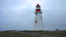
Point Riche Lighthouse
Appearance
 Point Riche Lighthouse | |
 | |
| Location | Port au Choix Newfoundland and Labrador Canada |
|---|---|
| Coordinates | 50°41′54″N 57°24′38″W / 50.6984°N 57.4105°W |
| Tower | |
| Constructed | 1871 (first) |
| Construction | wooden tower |
| Height | 5 metres (16 ft) |
| Shape | octagonal tower with balcony and lantern |
| Markings | white tower, red balcony and lantern |
| Operator | Port au Choix National Historic Site of Canada [1] |
| Heritage | recognized federal heritage building of Canada |
| Light | |
| First lit | 1892 (current) |
| Focal height | 29 metres (95 ft) |
| Range | 15 nautical miles (28 km; 17 mi) |
| Characteristic | Fl W 5s. |
Point Riche Lighthouse, located in Port au Choix, Newfoundland in Canada's Newfoundland and Labrador province, is a "pepperpot" lighthouse that was built in 1892 and is still active. The white wooden tower is octagonal pyramidal in shape, the lantern room is painted red. The structure is 19 metres (62 ft) tall. Its light characteristic is a flash every 5 seconds, emitted at a focal plane height of 29 metres (95 ft).[2] It is maintained by the Port au Choix National Historic Site.
The keeper's dwelling burned down in the 1970s.[3]
Keepers
[edit]- Eugene Roy 1871–1881
- Ferdinand Lemieux 1881–1896
- Narcisse Breton 1896–1926
- Joseph N. Romeo Breton 1926–1927
- Joseph Narcisse Gaudias Breton 1927–1959
- John Lawrence Rumbolt 1959–at least 1962[4]
See also
[edit]References
[edit]- ^ Rowlett, Russ. "Lighthouses of Canada: Southwestern Newfoundland". The Lighthouse Directory. University of North Carolina at Chapel Hill. Retrieved January 1, 2016.
- ^ Rowlett, Russ. "Lighthouses of Canada: Southwestern Newfoundland". The Lighthouse Directory. University of North Carolina at Chapel Hill. Retrieved 8 September 2008.
- ^ "Point Riche Lighthouse".
- ^ Lighthouse Friends
External links
[edit]Wikimedia Commons has media related to Point Riche lighthouse.
- Aids to Navigation Canadian Coast Guard
