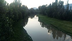
Pohru River
| Pohru River | |
|---|---|
 | |
| Location | |
| Country | India |
| Union Territory | Jammu and Kashmir |
| Region | Kashmir Valley |
| District | Baramulla, Kupwara |
| Physical characteristics | |
| Mouth | Jhelum River |
• coordinates | 34°15′56″N 74°25′03″E / 34.2656°N 74.4175°E |
| Depth | |
| • minimum | 2feet |
| • average | 5feet |
| • maximum | 9feet |
| Basin features | |
| Tributaries | |
| • left | Mawer river |
The Pohru River (Urdu: پہرو) is a right tributary of Jhelum River that flows through the Kupwara and Baramulla district of Kashmir region. Pohru river is formed by joining of Khamil Nallah and Lolab Nallah in the Kupwara town. Khamil Nallah originates from Shamashabri mountains in the Bangus valley and is joined by Budnamal Nallah at Chowkibal. Lolab Nallah is formed by confluence of several streams like Khurhama stream, Kalarose stream, Gund Machar stream etc. Mawer River is the main tributary of Pohru river, it originates from Kazinag Mountains and joins Pohru river at Ujroo Village of Langate tehsil. Pohru river passes through many villages where it finally enters into the jehum river near Doabgah [1] sopore town Baramullah district [2][3] Pohru River is one of the tributaries of the river Jhelum.[4]
References
[edit]- ^ "Google Maps". Google Maps. Retrieved 2024-02-12.
- ^ "Pohru River, Jammu And Kashmir, India - GeoYP.com". Retrieved 2021-05-09.
- ^ Central Ground Water Board. "District Profile Kupwara". Retrieved 10 May 2021.
- ^ Qazi, S. A. (2005). Systematic Geography of Jammu and Kashmir. APH Publishing. ISBN 978-81-7648-786-3.
