Pitschgau
Appearance
Pitschgau | |
|---|---|
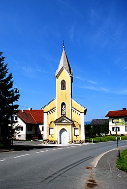
 Chapel in Pitschgau-Hörmsdorf | |
| Coordinates: 46°42′00″N 15°16′00″E / 46.70000°N 15.26667°E | |
| Country | Austria |
| State | Styria |
| District | Deutschlandsberg |
| Area | |
• Total | 12.19 km2 (4.71 sq mi) |
| Elevation | 355 m (1,165 ft) |
| Population (2014-01-01) | |
• Total | 1,586 |
| • Density | 130/km2 (340/sq mi) |
| Time zone | UTC+1 (CET) |
| • Summer (DST) | UTC+2 (CEST) |
| Postal code | 8552 |
| Area code | 3466 |
| Vehicle registration | DL |
| Website | www.pitschgau.gv.at |
Pitschgau was a municipality in Austria which merged in January 2015 into Eibiswald in the Deutschlandsberg District in the Austrian state of Styria.
Population
[edit]| Year | Pop. | ±% |
|---|---|---|
| 1869 | 1,009 | — |
| 1880 | 1,211 | +20.0% |
| 1890 | 1,332 | +10.0% |
| 1900 | 1,334 | +0.2% |
| 1910 | 1,572 | +17.8% |
| 1923 | 1,406 | −10.6% |
| 1934 | 1,285 | −8.6% |
| 1939 | 1,231 | −4.2% |
| 1951 | 1,490 | +21.0% |
| 1961 | 1,590 | +6.7% |
| 1971 | 1,687 | +6.1% |
| 1981 | 1,649 | −2.3% |
| 1991 | 1,589 | −3.6% |
| 2001 | 1,631 | +2.6% |
| 2011 | 1,578 | −3.2% |
| 2014 | 1,586 | +0.5% |
References
[edit]


