Pinhais
Appearance
Pinhais | |
|---|---|
 Buildings at the boundary between Pinhais and Curitiba | |
| Nickname(s): "Terra dos pinheirais" / "Morada da Gralha-Azul" (Land of the pine fields / Home of the Azure Jay) | |
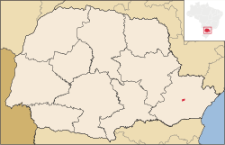
 Location of Pinhais in Paraná state and Brazil | |
| Coordinates: 25°25′57″S 49°11′36″W / 25.43250°S 49.19333°W | |
| Country | |
| Region | South |
| State | Paraná |
| Founded | March 20, 1992 |
| Government | |
| • Mayor | Luiz Goularte Alves (PT) |
| Area | |
• Total | 60.869 km2 (23.502 sq mi) |
| Elevation | 893 m (2,930 ft) |
| Population (2020 [2]) | |
• Total | 133,490 |
| • Density | 2,200/km2 (5,700/sq mi) |
| Time zone | UTC−3 (BRT) |
| HDI (2000) | 0.815 – high[3] |
| Website | www.pinhais.pr.gov.br |

Pinhais is a municipality in Paraná state in Brazil. As of 2020, the population was 133,490. It was emancipated from the municipality of Piraquara in 1992 and is part of the Metropolitan region of Curitiba. It is the smallest municipality in Paraná by area.
Education
[edit]This section needs expansion. You can help by adding to it. (April 2016) |
Private schools:
References
[edit]- ^ "Brazilian Institute of Geography and Statistics" (in Portuguese). 2017. Retrieved 27 March 2019.
2018 Area Total
- ^ IBGE 2020
- ^ [1] Archived 2009-10-03 at the Wayback Machine - UNDP
- ^ "Contact Archived 2016-05-09 at the Wayback Machine." Colégio Suíço-Brasileiro de Curitiba. Retrieved on April 25, 2016. "Street: Wanda dos Santos Mallmann, 537 Zip code: 83323-400 Pinhais (PR) - Brasil " - German Archived 2016-05-13 at the Wayback Machine, Portuguese Archived 2016-05-12 at the Wayback Machine
External links
[edit]Wikimedia Commons has media related to Pinhais.

